
Level 2 Severe Weather Risk Targets Kansas Oklahoma and North Texas Today With 2 Inch Hail Before Damaging Winds Push South Tonight
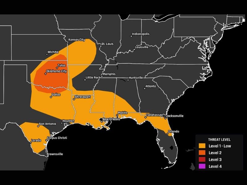
UNITED STATES — Severe weather could become active today from Kansas through Oklahoma and into North Texas, with the highest risk shown at Level 2 out of 5. Large hail up to 2 inches is possible this afternoon, followed by a stronger line of damaging winds moving south through the night. The broader low-end severe zone also stretches across parts of Texas, Louisiana, Mississippi, Alabama, Florida, and nearby Gulf Coast areas.
Level 2 Risk Centers on Oklahoma Into North Texas
The most focused severe weather risk is shown across Oklahoma and nearby North Texas, including areas near Oklahoma City, Tulsa, and Dallas. This Level 2 zone marks the area with the greatest concern for stronger storms today.
Storms in this corridor may become rowdy during the afternoon and evening. The setup supports large hail first, then a transition toward damaging wind potential later.
Large Hail Up to 2 Inches Possible This Afternoon
The early storm hazard is large hail, with some stones possibly reaching up to 2 inches. That size can damage vehicles, roofs, windows, and exposed outdoor property.
Residents in the highlighted risk zone should take hail seriously if storms develop nearby. Parking vehicles under cover and staying indoors during warnings would be the safer move.
Damaging Wind Line Moves South Through the Night
After the afternoon hail threat, a nasty line of storms may move south through the night. Damaging winds become the main concern as storms organize into a line and push toward North Texas.
This overnight timing may create added risk because people could be asleep when storms arrive. A way to receive weather alerts overnight will be important across the path.
Broader Low Risk Reaches the Gulf Coast
Outside the main Level 2 zone, a Level 1 risk stretches across parts of Texas, Louisiana, Mississippi, Alabama, Florida, and the Gulf Coast. Cities near Shreveport, Houston, New Orleans, Mobile, Tallahassee, and Jacksonville sit within the broader outlook.
Storms in these areas may be more scattered, but locally strong gusts, hail, lightning, and heavy rain remain possible. The main severe focus stays from Kansas to North Texas. Stay with NapervilleLocal.com for the latest weather updates and local forecast coverage.

I’ve lived in Naperville long enough to see how quickly our community changes — from new developments downtown to sudden shifts in our Midwest weather. Reporting on Naperville news and daily forecasts gives me the chance to keep neighbors informed about what really matters. My goal is simple: deliver clear, timely updates so you always know what’s happening in our city and what to expect from the skies above.