
Tornado Watch Active With EF1 Winds at 110mph and 55 to 70mph Gusts Targeting Florida Panhandle Including Pensacola, Panama City and Tallahassee Through Late Morning and Early Afternoon
FLORIDA PANHANDLE — An urgent tornado threat continues across the Gulf Coast states with the Florida Panhandle facing the most significant and active risk as of Thursday morning, May 7, 2026. Tornado Watch 189 and 190 are active across the region with a Mesoscale Discussion in place covering EF1 tornado potential at 110 mph, wind gusts of 55 to 70 mph, and hail up to 1.25 inches. Isolated tornado potential will continue through the late morning and early afternoon hours across the Panhandle corridor from Mobile and Pensacola through Panama City and Tallahassee.
Tornado Watch Active With EF1 Potential Across Florida Panhandle Through Late Morning
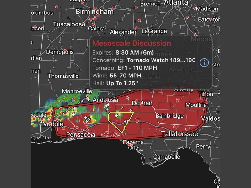
The active Tornado Watch covers a broad red zone stretching from Mobile and Pensacola eastward through Andalusia, Dothan, Panama City, and Tallahassee. EF1 tornado potential at winds reaching 110 mph is explicitly included in the Mesoscale Discussion, indicating that any tornado developing in this zone carries significant destructive potential.
A yellow highlighted area near Panama City and the central Panhandle represents the most focused and elevated tornado concern within the broader watch zone through the morning hours.
Wind Gusts of 55 to 70mph and 1.25 Inch Hail Accompany the Tornado Threat
Beyond tornado potential, the Mesoscale Discussion highlights wind gusts of 55 to 70 mph and hail up to 1.25 inches as accompanying hazards across the active tornado watch zone. These additional hazards make any storm that develops across the Panhandle potentially dangerous even without tornado formation.
Widespread lightning activity is already visible across Mobile, Pensacola, and the western Panhandle on current radar, with active storm cores pushing eastward through the region.
Isolated Tornado Potential Continues Through Late Morning and Early Afternoon
Storms have had difficulty maintaining severe strength through the morning hours, but isolated tornado potential remains real and active through the late morning and early afternoon window. Residents across Pensacola, Panama City, Tallahassee, Dothan, Bainbridge, and Valdosta must remain weather alert and shelter immediately if tornado warnings are issued for their specific location. Stay with NapervilleLocal.com for the latest weather updates and local forecast coverage.

I’ve lived in Naperville long enough to see how quickly our community changes — from new developments downtown to sudden shifts in our Midwest weather. Reporting on Naperville news and daily forecasts gives me the chance to keep neighbors informed about what really matters. My goal is simple: deliver clear, timely updates so you always know what’s happening in our city and what to expect from the skies above.