
Heavy Rain and Thunderstorms Causing Localized Flooding Across Central and Eastern North Carolina Including Raleigh, Fayetteville and Goldsboro Thursday Morning With Rain Lighter in Mountains
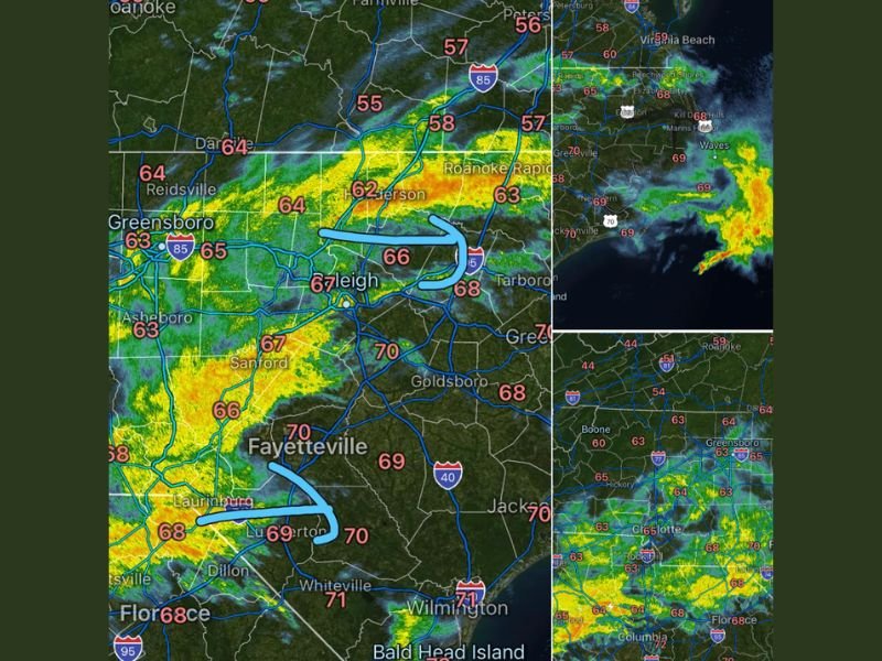
NORTH CAROLINA — Showers and thunderstorms continue moving across North Carolina as of the 9:53 AM Thursday update on May 7, 2026, with the heaviest and most impactful rainfall now focused across Central and Eastern NC. Some rain could be heavy at times across the Raleigh, Fayetteville, Goldsboro, and Tarboro corridors, leading to localized flooding from rapid runoff on streets during the heaviest rainfall periods. Across the mountains and foothills, rain is becoming lighter and more isolated as the system gradually pushes eastward through the morning.
Heavy Rain Possible at Times Across Central and Eastern NC With Localized Flooding
The most active radar returns at 9:53 AM are concentrated across central North Carolina, with intense yellow and orange cores tracking through the Raleigh, Sanford, Fayetteville, and Goldsboro zones. Temperatures across this active zone are running in the mid to upper 60s and near 70 degrees, adding humidity and moisture to the ongoing rainfall event.
Localized flooding from rapid runoff is a real concern during the heaviest rain periods across urban streets, intersections, and low-lying areas throughout Central and Eastern NC through the late morning hours.
Mountains and Foothills Seeing Lighter and More Isolated Rain Thursday Morning
Across the western portions of North Carolina including the mountains and foothills, rainfall is becoming lighter and more isolated as the main rain shield pushes eastward. Communities including Boone, Hickory, Charlotte, and the western foothills zone are tracking lighter green returns with temperatures in the low to mid 60s.
The Greensboro and Reidsville corridor sits in the transition zone between the heavier eastern activity and the lighter western coverage through the morning hours.
Eastern NC Coastal Zone Tracking Active Rain From Greenville Through Wilmington
The coastal zone from Greenville, Jacksonville, and Wilmington is tracking active rainfall as the storm system maintains coverage across Eastern NC. Temperatures along the coast are running in the upper 60s to near 70 degrees with continued rain and thunderstorm potential through the late morning and early afternoon hours before gradual improvement arrives. Stay with NapervilleLocal.com for the latest weather updates and local forecast coverage.

I’ve lived in Naperville long enough to see how quickly our community changes — from new developments downtown to sudden shifts in our Midwest weather. Reporting on Naperville news and daily forecasts gives me the chance to keep neighbors informed about what really matters. My goal is simple: deliver clear, timely updates so you always know what’s happening in our city and what to expect from the skies above.