
Another Blast of Cold Air Dropping Temperatures 10 to 15 Degrees Below Average Across the East Coast With Frost Possible May 11 Through May 15
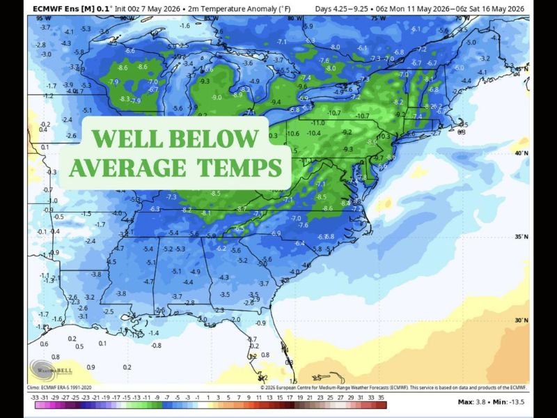
EAST COAST — Another significant blast of colder air is heading into the East Coast region during the May 11 through May 15, 2026 timeframe, bringing temperatures running 10 to 15 or more degrees below average across a broad zone stretching from the Great Lakes through the Mid-Atlantic and Southeast. European ensemble modeling initialized May 7 is showing well below average temperature anomalies deeply embedded across the entire eastern half of the country through mid-May. High temperatures will be limited to the mid 50s to mid 60s with calm and clear nights creating frost potential across vulnerable areas.
Temperatures Running 10 to 15 Plus Degrees Below Average May 11 Through 15
ECMWF ensemble data is showing temperature anomalies of negative 7 to negative 11 degrees across the core of the below average zone covering the Ohio Valley, Mid-Atlantic, and interior Northeast. Some of the deepest anomalies on the map reach negative 10 to negative 13 degrees across portions of Pennsylvania, New York, and the surrounding region.
The broad and deep nature of this cold air mass makes it a meaningful and impactful temperature departure rather than a brief overnight dip, affecting daytime highs across the entire East Coast corridor through the middle of May.
Mid 50s to Mid 60s Expected for Highs With Frost Risk on Clear Calm Nights
Despite average temperatures rapidly rising heading into mid-May, this cold blast will hold daytime highs in the mid 50s to mid 60s across much of the East Coast region through the May 11 to 15 window. The bigger concern comes overnight when calm and clear nights allow temperatures to drop sufficiently for frost development across sensitive areas.
Gardeners and agricultural interests across the region should closely monitor overnight temperature forecasts through mid-May and be prepared to protect sensitive plants and crops from potential frost damage.
Great Lakes and Mid-Atlantic Sitting Inside the Deepest Cold Anomaly Zone
The deepest cold anomalies on European ensemble modeling are concentrated across the Great Lakes, Ohio Valley, and Mid-Atlantic states, with negative 8 to negative 11 degree departures widespread through the region. The Southeast is also tracking well below average conditions, though anomalies are somewhat less extreme than the core northern zone through the May 11 to 15 period. Stay with NapervilleLocal.com for the latest weather updates and local forecast coverage.

I’ve lived in Naperville long enough to see how quickly our community changes — from new developments downtown to sudden shifts in our Midwest weather. Reporting on Naperville news and daily forecasts gives me the chance to keep neighbors informed about what really matters. My goal is simple: deliver clear, timely updates so you always know what’s happening in our city and what to expect from the skies above.