
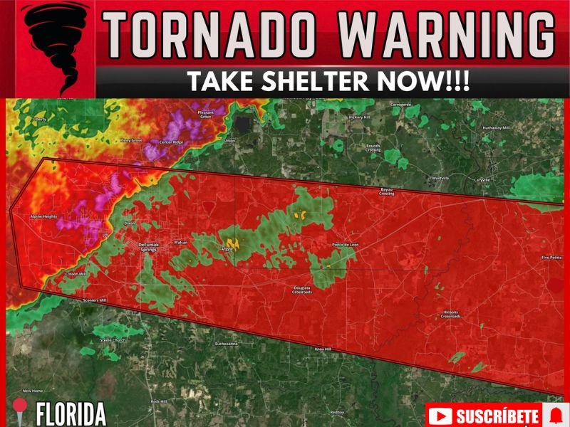
Tornado Warning Issued for Florida Panhandle as Severe Thunderstorm Capable of Producing Tornado Located Over De Funiak Springs Moving East at 60mph Take Shelter Now
FLORIDA PANHANDLE — A Tornado Warning has been issued for the Florida Panhandle as a severe thunderstorm capable of producing a tornado was located over De Funiak Springs, moving east at 60 mph on Thursday morning, May 7, 2026. The warning polygon covers a broad red zone stretching from De Funiak Springs eastward through Walcan, Argyle, Ponce de Leon, and surrounding communities. All residents inside the warned area must take shelter immediately in the lowest floor of a sturdy building away from all windows. This storm is moving rapidly and will impact communities across the warned zone in minutes.
Severe Thunderstorm Capable of Tornado Located Over De Funiak Springs Moving East
The warned storm was located directly over De Funiak Springs at the time of the warning issuance, producing an intense radar signature with pink and red returns indicating extreme precipitation rates and rotation. The storm is tracking east at 60 mph, an extremely fast movement speed that gives residents very little time to seek shelter before impacts arrive.
Communities in the direct path including Walcan, Argyle, Ponce de Leon, and Bayou Crossing are in immediate danger and must shelter without any delay.
Warning Polygon Covers Broad Zone From De Funiak Springs Through Ponce de Leon
The Tornado Warning polygon covers an expansive red zone across the Florida Panhandle, stretching from the western edge near Alpine Heights and Cotton Mill through De Funiak Springs, Dixon, Walcan, Argyle, Ponce de Leon, and eastward toward Five Points and Hinsons Crossroads. The broad width of the polygon reflects the storm’s size and the uncertainty in tornado touchdown location.
Anyone inside this warning zone regardless of their exact location must treat this as an immediate life threatening situation and seek sturdy shelter right now.
All Residents Inside the Warning Zone Must Take Shelter Immediately
The 60 mph eastward movement of this storm makes every second critical for residents across the warned area. Move to an interior room on the lowest floor of a sturdy structure immediately, away from all windows, and do not leave shelter until the warning has expired and local authorities confirm it is safe. Stay with NapervilleLocal.com for the latest weather updates and local forecast coverage.

I’ve lived in Naperville long enough to see how quickly our community changes — from new developments downtown to sudden shifts in our Midwest weather. Reporting on Naperville news and daily forecasts gives me the chance to keep neighbors informed about what really matters. My goal is simple: deliver clear, timely updates so you always know what’s happening in our city and what to expect from the skies above.