
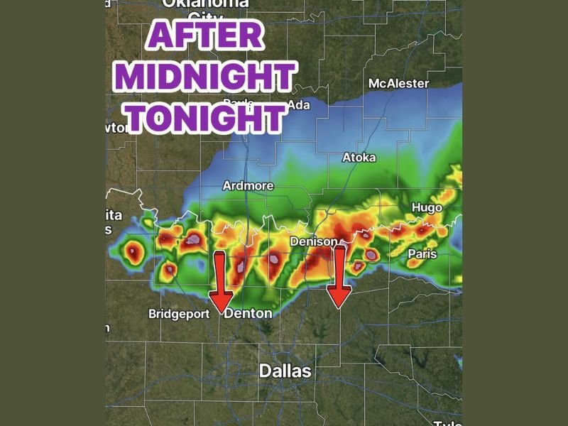
Large Hail and Damaging Wind Risk Moves From Oklahoma Into North Texas After Midnight With Strongest Storms North of Highway 380
NORTH TEXAS — Strong to severe storms are expected to build in Oklahoma late Friday afternoon before diving south overnight into North Texas. The strongest storms are expected in northern counties north of Highway 380 after midnight, with hail, stronger wind gusts, lightning, and heavy rain possible. Storms should weaken farther south, reaching Dallas in a weaker form during the early morning hours.
Oklahoma Storm Complex Moves South Overnight
Storms are expected to first organize across Oklahoma late Friday afternoon, where large hail and damaging winds may develop. This complex will then begin moving south overnight toward the Red River and North Texas.
The main timing for North Texas appears to be after midnight. Areas closer to the Oklahoma border will have the better chance to see stronger storms before the system weakens.
Strongest Storms Focus North of Highway 380
The highest concern is for northern counties north of Highway 380, including areas near Denton and Denison. These locations are closest to the stronger part of the storm complex as it crosses into North Texas.
Hail, stronger wind gusts, lightning, and heavy rain are possible in this zone. The storms should gradually lose intensity the farther south they move.
Dallas May See Weaker Storms in the Early Morning
Dallas is expected to see the storm complex arrive later, mainly in the wee hours of the morning. By that time, the storms are expected to be weaker compared with areas farther north.
Rain and thunder may still move through parts of the metro, but the stronger severe threat appears more focused north of the city. Residents should still stay aware overnight in case storms hold together longer than expected.
Scattered Showers South of I-20 Before Fizzling Out
After moving through the Dallas area, the complex should continue weakening. Scattered showers may continue south of I-20 before the activity fizzles out.
The overnight setup is not expected to bring the same storm strength everywhere. The key area to watch remains North Texas north of Highway 380 after midnight. Stay with NapervilleLocal.com for the latest weather updates and local forecast coverage.

I’ve lived in Naperville long enough to see how quickly our community changes — from new developments downtown to sudden shifts in our Midwest weather. Reporting on Naperville news and daily forecasts gives me the chance to keep neighbors informed about what really matters. My goal is simple: deliver clear, timely updates so you always know what’s happening in our city and what to expect from the skies above.