
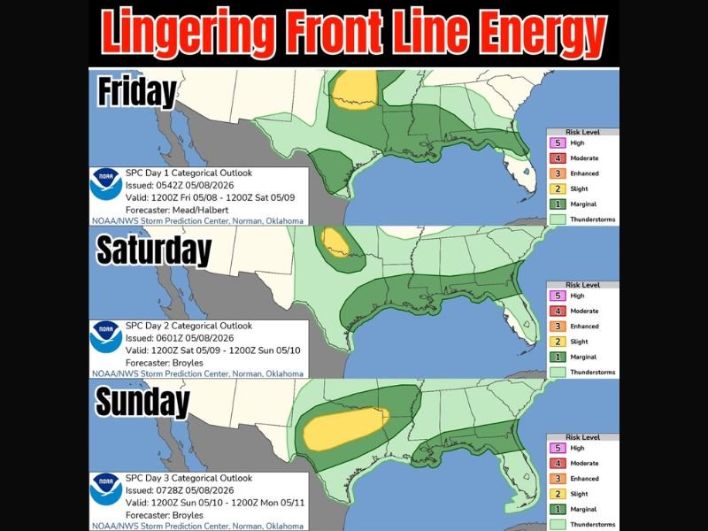
Lingering Front Line Keeps Marginal Storm Chances Across Southeast and Upper Gulf Friday Through Sunday With Bigger Rain Pockets Possible
SOUTHEAST UNITED STATES — A lingering front line will keep storm chances repeating across the Southeast and upper Gulf Coast through the weekend. The setup shows a Level 1 out of 5 marginal severe storm risk at times, with thunderstorm chances stretching from Texas and Louisiana toward Mississippi, Alabama, Georgia, and Florida. Some areas may see bigger rainfall totals, while middle and lower Florida, especially west-central Florida, stays much lower on expected totals.
Friday Storm Chances Stretch Across the Upper Gulf and Southeast
Friday’s setup shows marginal storm chances across parts of the upper Gulf region and Southeast. The risk zone includes areas from Texas and Louisiana into Mississippi, Alabama, Georgia, and northern Florida.
This is not shown as a major severe weather setup, but storms may still develop along the lingering front. The main concern is repeated thunderstorm activity where the boundary remains active.
Saturday Keeps the Same Pattern on Repeat
Saturday continues the unsettled pattern, with storm chances still focused along the Southeast and Gulf Coast states. The map again shows a broad thunderstorm zone with Level 1 out of 5 marginal risk in parts of the region.
The front line energy remains in place, which means scattered storms may redevelop instead of clearing out quickly. Some spots could stay dry longer, while others may see repeated rounds.
Sunday Brings Another Storm Window West of the Gulf States
By Sunday, the storm focus shifts more toward the western Gulf and nearby southern Plains areas. A slight risk zone appears farther west, while marginal storm chances still extend toward the lower Mississippi Valley and parts of the Southeast.
This suggests the weekend pattern does not fully shut down after Saturday. Areas closer to the active boundary may still need to watch for locally stronger storms and heavier rainfall.
Florida Rain Totals Stay Lower in Central and Southern Areas
The data notes that the middle and lower Florida peninsula are not expected to see much in rainfall totals. West-central Florida is especially highlighted as staying drier compared with areas farther north.
For the broader Southeast and upper Gulf, the key message is a stormy weekend pattern driven by the lingering front. Rainfall may be uneven, with bigger totals possible in some locations and lighter totals in others. Stay with NapervilleLocal.com for the latest weather updates and local forecast coverage.

I’ve lived in Naperville long enough to see how quickly our community changes — from new developments downtown to sudden shifts in our Midwest weather. Reporting on Naperville news and daily forecasts gives me the chance to keep neighbors informed about what really matters. My goal is simple: deliver clear, timely updates so you always know what’s happening in our city and what to expect from the skies above.