
Gusty Winds and Brief Tornado Risk Targeting Coastal and Eastern NC Including Raleigh and Fayetteville Monday Afternoon With Scattered Showers Moving Northeast Across Virginia and Western NC
NORTH CAROLINA AND VIRGINIA — Scattered showers are moving across northwest sections of North Carolina and into southern Virginia as of the 9:55 AM Monday update on May 11, 2026, tracking mostly northeast with some isolated activity pushing east. Further east along the coast and in Eastern NC, a few scattered to isolated showers and thunderstorms will develop after lunch into the mid-afternoon hours. A low risk of severe storms exists along the NC coast and parts of Eastern NC, with gusty damaging winds the primary concern and a brief tornado remaining possible though unlikely.
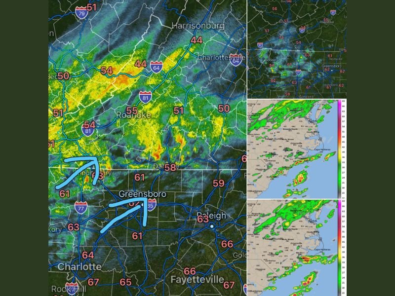
Scattered Showers Across Northwest NC and Southern Virginia Moving Northeast at 9:55AM
Current radar is showing active green and yellow returns across the northwest NC and southern Virginia corridor, covering areas from the Charlotte metro through Greensboro, Roanoke, Harrisonburg, and Charlottesville. Temperatures across the region are running in the low to mid 60s across central NC and upper 50s through the Virginia mountain zones.
These showers will continue tracking mostly northeast through the morning hours with isolated activity pushing eastward as the system progresses through the region.
Coastal and Eastern NC Faces Low Severe Risk After Lunch Into Mid-Afternoon
A separate and more organized storm development threat will emerge along the NC coast and Eastern NC after lunch, with scattered to isolated showers and thunderstorms developing through the mid-afternoon hours. Future radar imagery shows storm activity developing along the coastal zone from the Outer Banks through Wilmington and Cape Hatteras during the afternoon window.
The low severe risk is not high but a damaging wind gust cannot be ruled out with stronger storm cells developing along the coast through the afternoon.
Brief Tornado Cannot Be Ruled Out Though Gusty Winds Remain the Greater Threat
The tornado threat across coastal and Eastern NC is described as very low, but a brief tornado cannot be completely eliminated as a possibility during the afternoon storm development window. Gusty and potentially damaging winds represent the more likely and greater hazard with any storms that organize along the coast and Eastern NC through the Monday afternoon hours.
Stay with NapervilleLocal.com for the latest weather updates and local forecast coverage.

I’ve lived in Naperville long enough to see how quickly our community changes — from new developments downtown to sudden shifts in our Midwest weather. Reporting on Naperville news and daily forecasts gives me the chance to keep neighbors informed about what really matters. My goal is simple: deliver clear, timely updates so you always know what’s happening in our city and what to expect from the skies above.