
May Tornado and Severe Weather Risk Peaks Over Central Plains Iowa Ohio Valley and Southern Michigan With Activity Expected to Ramp Up Later This Month
UNITED STATES — May is historically the most active month for severe weather and tornadoes across the United States, with the greatest risk corridor stretching from the central plains northward into Iowa and across the Ohio Valley. While the month has been relatively quiet so far, early signals suggest severe weather activity could increase significantly as the back half of May approaches. Residents across all elevated risk zones should stay prepared and weather-aware through the remainder of the month.
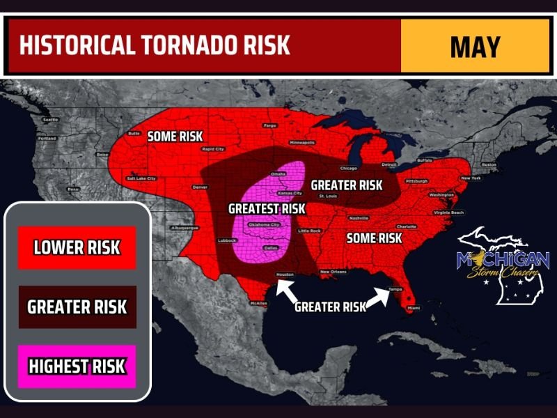
Greatest Tornado Risk Centered Over Central Plains Oklahoma City Dallas and Kansas City Corridor
The highest risk zone covers the heart of Tornado Alley, centered over the central plains and extending through areas including Oklahoma City, Dallas, Lubbock, and the Kansas City corridor. This region sees the heaviest concentration of tornado reports during May, driven by the reliable overlap of moisture, instability, wind shear, and lift that comes together over this area more than anywhere else in the country this time of year.
When the pattern turns active across this zone, significant and long-track tornado events become a very real possibility. Residents here carry the highest level of exposure through the remainder of the month.
Greater Risk Zone Fans Into Ohio Valley Chicago Southern Michigan and Gulf Coast Areas
Beyond the central plains core, a broader greater risk zone extends into the Ohio Valley, southern lower Michigan, the Chicago metro region, and along the Gulf Coast through New Orleans and into the Tampa area. These regions see a meaningful increase in tornado frequency during May compared to other months of the year.
The reach of elevated risk into the Midwest including Chicago and southern Michigan is an important reminder that tornado threats during May are not exclusive to traditional Tornado Alley. The entire highlighted corridor deserves the same level of preparedness and situational awareness.
Severe Weather Activity Shows Signs of Increasing Across Risk Zones Later This Month
May has started quietly across much of the country, but that calm is not expected to last through the end of the month. Forecasters are seeing early pattern signals that suggest severe weather could ramp up across multiple risk zones as the month progresses into its final weeks.
With the most climatologically active period of the year still unfolding, anyone living within the lower risk, greater risk, or highest risk zones shown on the map should confirm their severe weather plans now. Knowing shelter locations and having active weather alerts in place before the next active pattern arrives is the smartest step anyone can take right now. Stay with NapervilleLocal.com for the latest weather updates and local forecast coverage.

I’ve lived in Naperville long enough to see how quickly our community changes — from new developments downtown to sudden shifts in our Midwest weather. Reporting on Naperville news and daily forecasts gives me the chance to keep neighbors informed about what really matters. My goal is simple: deliver clear, timely updates so you always know what’s happening in our city and what to expect from the skies above.