
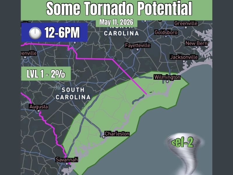
Tornado Threat Targets Carolina Coastline From Wilmington NC to Beaufort and Charleston SC With Spin-Up Risk This Afternoon Between Noon and 6 PM
CAROLINAS — A low-end but legitimate tornado threat is in place along the Carolina coastline today, May 11, 2026, with the active window running from noon through 6 PM. One or two discrete storm cells are expected to develop across the coastal corridor, and enough wind shear exists in the atmosphere to support brief rotation within those storms. Any tornado that forms is expected to stay weak, but the threat is real and deserves attention from residents and visitors along the affected stretch of coastline.
Coastal Corridor From Wilmington Through Charleston Sits Inside the Primary Threat Zone
The green-shaded risk area on today’s outlook covers a meaningful stretch of the Carolina coast, running from Wilmington, North Carolina southward through Beaufort and into the Charleston, South Carolina region. This zone is where atmospheric ingredients come together well enough to support isolated storm development and brief spin-up tornadoes this afternoon.
Storms that manage to stay discrete and avoid merging into larger clusters will carry the highest tornado potential. The coastal environment can sometimes allow cells to stay organized longer, which makes this corridor worth watching closely through the early evening.
Level 1 Outlook Carries a 2 Percent Tornado Probability With Sub-EF2 Intensity Expected
Today’s tornado outlook is rated Level 1 at 2 percent probability, which reflects a low-end but non-zero threat across the highlighted zone. All tornadoes are forecast to remain below EF-2 intensity, meaning any that develop would be relatively short-lived and narrow in their damage path.
The setup is not dramatic, but discrete cell development in a shear-supportive environment is exactly the scenario that produces brief, hard-to-anticipate spin-ups. These types of tornadoes can touch down quickly and with limited warning time, even on a day that does not look threatening on the surface.
Outdoor Plans Along the Carolina Coast This Afternoon Require a Real-Time Alert Plan
Residents, tourists, and anyone spending time outdoors between Wilmington and the Lowcountry this afternoon should have weather alerts active on their phone before heading out. Tornadoes in coastal setups like this one can develop fast, and having shelter identified in advance makes a significant difference in response time.
Boaters, beach visitors, and outdoor event attendees across this corridor face the highest exposure during the noon to 6 PM window. Keeping an eye on radar and staying flexible with afternoon plans is the smartest approach today. Stay with NapervilleLocal.com for the latest weather updates and local forecast coverage.

I’ve lived in Naperville long enough to see how quickly our community changes — from new developments downtown to sudden shifts in our Midwest weather. Reporting on Naperville news and daily forecasts gives me the chance to keep neighbors informed about what really matters. My goal is simple: deliver clear, timely updates so you always know what’s happening in our city and what to expect from the skies above.