
Downburst Winds Exceeding 70mph Targeting Central Montana Eastern Idaho and Northern Utah Including Helena Billings Idaho Falls and Salt Lake City This Afternoon Between 3PM and 8PM
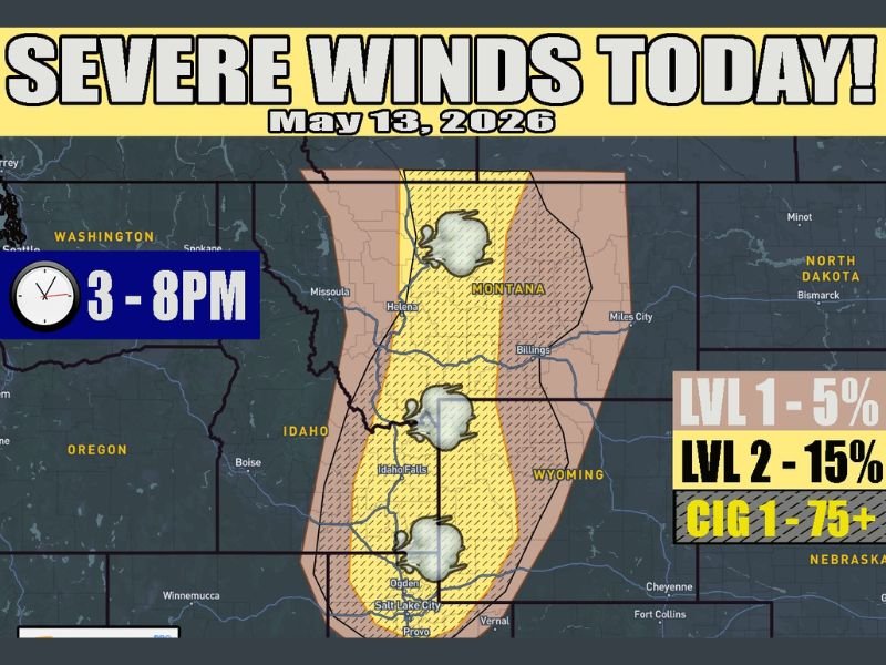
MONTANA — A Level 2 severe weather threat is in place today, May 13, 2026, across central Montana into eastern Idaho and northern Utah, with high-based showers and storms capable of producing destructive downburst winds in excess of 70 mph during the primary threat window running from 3:00 PM through 8:00 PM. This marks the first Level 2 severe storm zone of the year for this region, making today a significant and noteworthy weather event across the Northwest.
The core yellow-shaded area carries a 15 percent wind probability and a CIG 1 rating of 75 or greater, confirming high confidence in significant wind damage potential this afternoon. Communities including Helena, Billings, Idaho Falls, Ogden, Salt Lake City, and Provo all fall within or near the outlined threat corridor and should remain on high alert through the evening hours.
Level 2 Wind Threat Covers Central Montana Into Eastern Idaho With 15 Percent Probability
The yellow-shaded Level 2 core running from central Montana southward through eastern Idaho and into northern Utah carries the highest wind damage risk of today’s setup. A 15 percent damaging wind probability is in place across this corridor, reflecting genuine confidence that downburst winds exceeding severe criteria will occur during the afternoon and evening hours.
The broader tan-shaded Level 1 zone surrounding the core carries a 5 percent wind probability and extends the threat outward to include a wider swath of the region. Any storm firing within either zone today has the potential to produce sudden and dangerous wind gusts capable of causing significant property damage and creating hazardous travel conditions.
High Based Storms Capable of 70mph Plus Downbursts From Helena Through Salt Lake City Corridor
High-based showers and thunderstorms are the primary storm mode driving today’s wind threat across the region. These types of storms produce powerful downburst winds when precipitation evaporates in dry air below the cloud base, creating a column of rapidly descending air that accelerates and spreads outward at the surface with destructive force.
Winds exceeding 70 mph in these events can down trees, damage structures, and create extremely dangerous driving conditions with little to no warning. The Helena through Idaho Falls and Salt Lake City corridor sits directly in the highest risk zone and should treat this afternoon as a serious wind event.
Tornado Risk Remains Very Low While Small Hail Possible With Stronger Updrafts
Tornado potential with today’s storm setup is described as very low and is not a significant concern across the outlined zone. While no hail zone has been formally highlighted, isolated pea-sized hail remains possible with any stronger updraft that develops given colder temperatures present at higher altitudes in the atmosphere.
Anyone across central Montana, eastern Idaho, and northern Utah should secure loose outdoor items, avoid unnecessary travel during the 3:00 PM to 8:00 PM window, and stay away from trees and power lines if winds begin to intensify in their area this afternoon. Stay with NapervilleLocal.com for the latest weather updates and local forecast coverage.

I’ve lived in Naperville long enough to see how quickly our community changes — from new developments downtown to sudden shifts in our Midwest weather. Reporting on Naperville news and daily forecasts gives me the chance to keep neighbors informed about what really matters. My goal is simple: deliver clear, timely updates so you always know what’s happening in our city and what to expect from the skies above.