
Heat Surging Into the 80s and 90s Across Colorado Including Denver Front Range and Western Slope With Scattered Storms and Gusty Winds Tuesday Through the Weekend
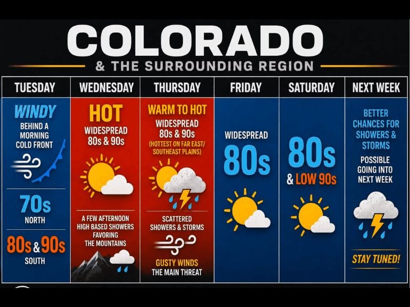
COLORADO — A week of building heat, scattered storms, and gusty winds is taking shape across Colorado and the surrounding region, with temperatures climbing into widespread 80s and 90s beginning Wednesday and holding through the weekend. A morning cold front is keeping northern areas in the 70s on Tuesday while southern locations along and south of Highway 50 are already touching the 80s and 90s, with the western slope seeing the hottest readings near the mid-90s. The pattern turns more active by Wednesday and Thursday before a potentially cooler and stormier stretch arrives next week.
Tuesday Stays Quiet With Cold Front Keeping North in the 70s While South Touches the 90s
Tuesday is the calmest day of the week for most of Colorado, with a morning cold front keeping northern portions of the state comfortably in the 70s. South of Highway 50, temperatures are climbing well into the 80s and touching the low 90s, with the western slope reaching the mid-90s as the hottest zone in the region today. A few extra clouds are expected this afternoon but overall conditions remain relatively quiet statewide.
Wednesday Turns Hot With Widespread 80s and 90s and Afternoon Mountain Showers Possible
Flow returns from the south and southwest on Wednesday, sending temperatures rebounding quickly east of the Continental Divide into widespread 80s and low 90s. The warmest readings will once again focus along the South Platte River corridor, Highway 50, and the western slope where near-90-degree temperatures are expected. A few scattered high-based showers are possible Wednesday afternoon favoring the mountains, but gusty winds are likely the bigger story as much of that precipitation evaporates before reaching the ground.
Thursday Brings Scattered Storms and Gusty Winds With Heat Persisting Into the Weekend
Thursday increases storm chances across the region with scattered showers and thunderstorms developing statewide. The western slope cools into the mid-80s while areas east of the Continental Divide remain a mix of 80s and 90s, with gusty winds emerging as the primary threat alongside any storm that develops. Friday brings widespread 80s before the weekend settles into a mix of 80s and low 90s, with the hottest temperatures focused along Highway 50 into western Kansas. Next week is worth watching closely as models hint at a cooler pattern returning with better shower and thunderstorm chances by Monday. Stay with NapervilleLocal.com for the latest weather updates and local forecast coverage.

I’ve lived in Naperville long enough to see how quickly our community changes — from new developments downtown to sudden shifts in our Midwest weather. Reporting on Naperville news and daily forecasts gives me the chance to keep neighbors informed about what really matters. My goal is simple: deliver clear, timely updates so you always know what’s happening in our city and what to expect from the skies above.