
Damaging Winds and Very Large Hail Targeting Texas Through Wisconsin Including Kansas City Omaha Wichita Chicago and St Louis Late Afternoon Into Evening Friday May 15
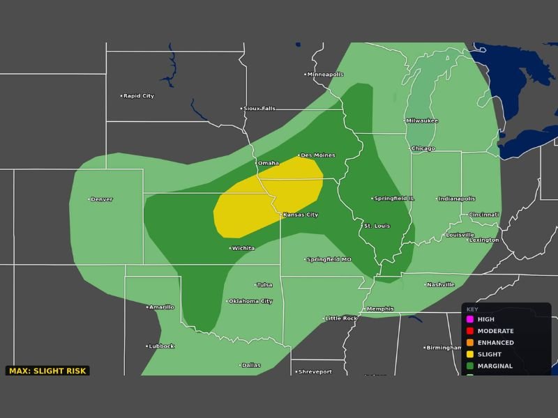
CENTRAL PLAINS — A large and dangerous severe weather setup is taking shape for Friday, May 15, 2026, with damaging winds and very large hail expected across a wide corridor stretching from Texas northward through Wisconsin. The Slight Risk core is centered over the Kansas City and Omaha corridor, with a broad Marginal Risk zone extending the threat outward through Chicago, Milwaukee, St. Louis, Springfield, Des Moines, and Sioux Falls.
Storms will be most dangerous during the late afternoon and well into the evening hours across the outlined zones. The threat zone covers an enormous geographic footprint from the southern Plains all the way into the Upper Midwest, meaning millions of people across multiple states need to remain weather aware heading into Friday afternoon.
Slight Risk Core Centered Over Kansas City and Omaha With Damaging Winds and Large Hail
The yellow Slight Risk zone centered over Kansas City and extending through the Omaha and Des Moines corridor carries the highest confidence for significant severe weather Friday. Damaging winds and very large hail are the primary threats within this core zone during the late afternoon and evening hours, with storms expected to be at their most intense and organized during this window.
Any storm developing within the Slight Risk zone should be treated as immediately dangerous, as the atmospheric environment supports rapid intensification and sustained severe weather production through the evening hours.
Marginal Risk Fans Outward Through Chicago Milwaukee St Louis and Springfield Illinois
Surrounding the Slight Risk core, a broad Marginal Risk zone covers a large swath of the central United States including Chicago, Milwaukee, St. Louis, Springfield Illinois, Indianapolis, and Memphis. Communities across this wider zone carry a lower but still real threat for damaging winds and large hail Friday afternoon and evening.
The geographic scale of the Marginal Risk coverage means that even areas away from the highest risk core should not treat Friday as a routine weather day. Severe storms can and do occur within Marginal Risk zones, particularly during setups where a nearby Slight Risk core is driving an active and organized storm environment.
Storms Most Dangerous During Late Afternoon and Evening Hours Across All Risk Zones
Timing is a critical factor for Friday’s severe weather threat, with storms expected to reach their most dangerous phase during the late afternoon and well into the evening hours. That timing window overlaps with evening commutes, outdoor activities, and events across the entire outlined corridor from Texas through Wisconsin.
Anyone with outdoor plans Friday afternoon or evening should have weather alerts active and shelter plans confirmed well in advance of storm development across the region. Stay with NapervilleLocal.com for the latest weather updates and local forecast coverage.

I’ve lived in Naperville long enough to see how quickly our community changes — from new developments downtown to sudden shifts in our Midwest weather. Reporting on Naperville news and daily forecasts gives me the chance to keep neighbors informed about what really matters. My goal is simple: deliver clear, timely updates so you always know what’s happening in our city and what to expect from the skies above.