
Extreme to Exceptional Drought Gripping Central Florida Including Tampa St Petersburg Sarasota and Bradenton With No Major Improvement Despite Recent Rainfall
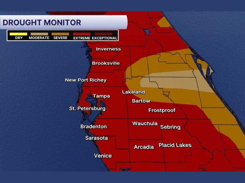
FLORIDA — The latest Drought Monitor update confirms that extreme to exceptional drought conditions continue to grip a large portion of Central Florida with no major change in drought levels despite Tuesday’s rainfall. The map shows deep red extreme and exceptional drought coverage blanketing the Tampa Bay area, Sarasota, Venice, Bradenton, and communities stretching southward, underscoring just how severe and entrenched the current drought situation has become across the region.
Tuesday’s rain, while welcome, made no meaningful dent in the historic rainfall deficit facing this part of Florida. The absence of any significant improvement in drought categories following a rain event speaks directly to the extraordinary depth of the current drought across Central Florida and the massive amount of sustained rainfall needed to reverse it.
Extreme and Exceptional Drought Covers Tampa Bay Sarasota Bradenton and Venice Corridor
The most severe drought categories on the monitor — extreme and exceptional — cover the bulk of the mapped area across the Tampa Bay corridor southward through Bradenton, Sarasota, and Venice. These categories represent the deepest levels of drought intensity on the scale and reflect months of accumulated rainfall deficits that a single rain event cannot address.
Communities including Tampa, St. Petersburg, New Port Richey, Brooksville, and Inverness all sit within or immediately adjacent to the extreme drought footprint. The breadth of coverage across this densely populated corridor makes this one of the more significant drought situations Central Florida has faced in recent memory.
Severe and Moderate Drought Extends Into Lakeland Bartow and Frostproof Corridor
East of the most intense drought core, a transition zone of severe and moderate drought conditions covers the Lakeland, Bartow, Frostproof, Wauchula, Sebring, Arcadia, and Placid Lakes corridor. While these categories are less severe than the extreme and exceptional zones to the west, they still represent significant moisture deficits requiring sustained rainfall over multiple months to resolve.
The gradual easing of drought intensity moving east across the map reflects slightly better recent rainfall totals in that zone compared to the coast, but conditions remain well below normal across the entire outlined region.
Recent Rainfall Made No Major Change Highlighting the Severity of the Current Drought
Tuesday’s rainfall was captured in the latest Drought Monitor update but produced no major category improvements across any portion of the mapped area. That outcome reinforces just how deep and serious the current drought situation is across Central Florida, where isolated rain events are simply absorbed by the deficit without registering meaningful recovery.
Sustained and repeated rainfall over the coming weeks and months through the rainy season will be required before any significant drought improvement is reflected on future monitor updates. Stay with NapervilleLocal.com for the latest weather updates and local forecast coverage.

I’ve lived in Naperville long enough to see how quickly our community changes — from new developments downtown to sudden shifts in our Midwest weather. Reporting on Naperville news and daily forecasts gives me the chance to keep neighbors informed about what really matters. My goal is simple: deliver clear, timely updates so you always know what’s happening in our city and what to expect from the skies above.