
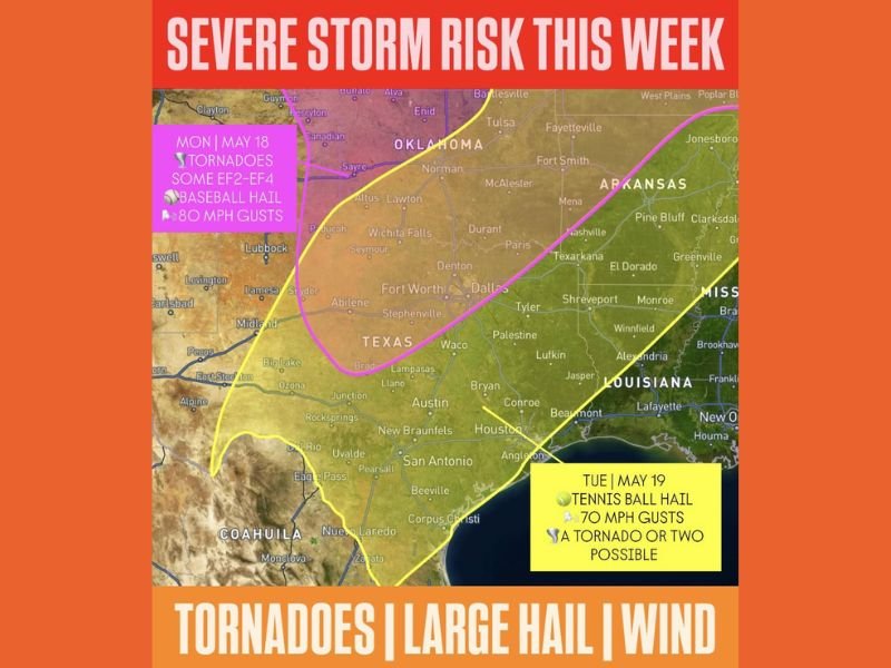
EF2 to EF4 Tornadoes Baseball Hail and 80mph Gusts Targeting Oklahoma and Texas Including Oklahoma City Fort Worth Dallas and Wichita Falls Monday With Tennis Ball Hail Tuesday
OKLAHOMA — A dangerous two-day severe weather outbreak is targeting Oklahoma and Texas this week, with Monday carrying the most extreme threat including EF2 to EF4 tornadoes, baseball size hail, and wind gusts reaching 80 mph across the outlined pink risk zone. Tuesday brings a second round focused across Texas with tennis ball size hail, 70 mph gusts, and a tornado or two possible across the southern corridor. Residents across both states need to be fully weather aware through Tuesday evening.
Monday Brings EF2 to EF4 Tornadoes Baseball Hail and 80mph Gusts Across Oklahoma Into North Texas
The pink risk zone covering Oklahoma through north Texas on Monday, May 18 represents an extremely dangerous severe weather setup with violent tornado potential. EF2 to EF4 tornadoes, baseball size hail, and 80 mph wind gusts are all on the table for communities including Oklahoma City, Norman, Lawton, Wichita Falls, Fort Worth, and Dallas through Monday afternoon and evening.
This is a life-threatening severe weather situation for the outlined zone and residents must have shelter plans confirmed before storms arrive.
Tuesday Shifts Focus South With Tennis Ball Hail and 70mph Gusts Across Texas
Tuesday’s risk shifts southward across Texas, bringing tennis ball size hail, 70 mph wind gusts, and the possibility of a tornado or two across the yellow outlined zone. The Tuesday threat covers a broad area from north Texas southward through the Dallas, Waco, Austin, and Houston corridor extending into Louisiana.
Tennis ball size hail is capable of causing catastrophic damage to vehicles, roofs, and any exposed property across the affected communities.
All Residents Across Oklahoma and Texas Must Prepare Now for Back to Back Dangerous Days
With two consecutive days of life-threatening severe weather targeting Oklahoma and Texas, preparation cannot wait. Confirming shelter locations, moving vehicles under cover, and having multiple ways to receive warnings active before Monday afternoon are the most critical steps for anyone in the outlined risk zones this week. Stay with NapervilleLocal.com for the latest weather updates and local forecast coverage.

I’ve lived in Naperville long enough to see how quickly our community changes — from new developments downtown to sudden shifts in our Midwest weather. Reporting on Naperville news and daily forecasts gives me the chance to keep neighbors informed about what really matters. My goal is simple: deliver clear, timely updates so you always know what’s happening in our city and what to expect from the skies above.