
Major Storm System Bringing Snow Wind Rain and Fire Danger Across Colorado Wyoming and Nebraska Including Denver Front Range and I-80 Corridor With Widespread Impacts Monday
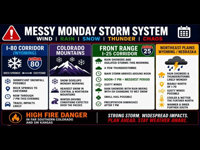
COLORADO — A messy and impactful storm system is marching across Colorado, Wyoming, and Nebraska Monday, May 18, 2026, bringing a combination of significant snowfall, rain, thunderstorms, gusty winds, and high fire danger simultaneously across different zones. The I-80 corridor from Rock Springs to Cheyenne faces significant snowfall and travel impacts through 7 PM, Colorado mountains are seeing heavy snow with winter driving conditions over the passes, and the Front Range I-25 corridor faces its messiest period between noon and 7 PM. High fire danger is simultaneously gripping far southern Colorado and SW Kansas.
I-80 Corridor From Rock Springs to Cheyenne Faces Significant Snow and Travel Impacts Through 7PM
Significant snowfall is possible along the Wyoming I-80 corridor from Rock Springs eastward to Cheyenne through 7 PM this evening. Travel impacts are likely across this stretch, making the I-80 corridor between Rock Springs and Cheyenne extremely dangerous for drivers through tonight. Anyone with planned travel along this corridor should delay until conditions improve or expect significant weather-related disruptions.
Colorado Mountains See Heavy Snow With Winter Driving Conditions Over the Passes
Snow is developing across the Colorado mountains Monday morning with the heaviest accumulations expected across the central and northern mountain ranges. Winter driving conditions are expected over the higher passes, making mountain travel treacherous through the day. The western slope and San Juans will also see periods of lower elevation rain and storms ending later this afternoon before conditions improve.
Front Range I-25 Corridor Faces Messiest Period Noon to 7PM With Rain Snow Thunder and Hail
The Front Range and I-25 corridor faces an active and messy storm window from noon through 7 PM Monday. Rain showers, isolated thunderstorms, gusty winds, small hail, and rain mixing with or changing to wet snow are all possible during this peak impact period, with precipitation diminishing after 7 PM.
Snow accumulation is possible in the foothills while lower elevations would see sporadic wet snow confined mainly to grassy surfaces.
High Fire Danger Grips Southern Colorado and SW Kansas While Northeast Plains See Storms
Far southern Colorado and SW Kansas face high fire danger Monday with warm, dry, and windy conditions creating critical fire weather. Meanwhile the northeast plains of Colorado, Wyoming, and Nebraska see rain showers and thunderstorms likely mainly north of I-70 with gusty winds and cooler temperatures through the day. Stay with NapervilleLocal.com for the latest weather updates and local forecast coverage.

I’ve lived in Naperville long enough to see how quickly our community changes — from new developments downtown to sudden shifts in our Midwest weather. Reporting on Naperville news and daily forecasts gives me the chance to keep neighbors informed about what really matters. My goal is simple: deliver clear, timely updates so you always know what’s happening in our city and what to expect from the skies above.