
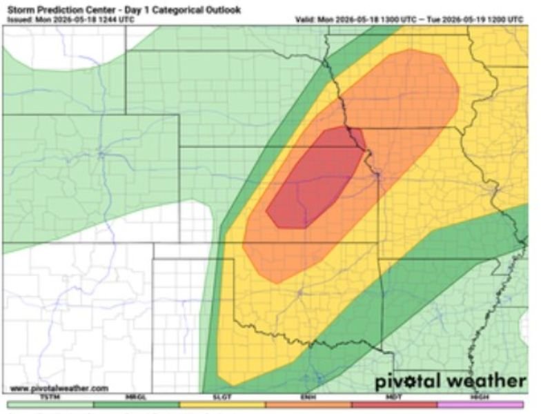
EF4 Tornado Threat and Softball Size Hail Confirmed Across Moderate Risk Zone Covering Iowa Illinois and Missouri With SPC Day 1 Outlook Issued Monday May 18
IOWA — Forecast soundings across the Moderate Risk area are now supporting tornadoes up to EF4 intensity and softball size hail Monday, May 18, 2026, representing one of the most dangerous severe weather confirmations issued for this region in recent memory. The SPC Day 1 Categorical Outlook shows the red Moderate Risk core centered over the Iowa, Illinois, and Missouri border region, surrounded by a broad Enhanced Risk orange zone and a large Slight Risk yellow zone extending outward. Everyone inside and surrounding the outlined risk zones must have a tornado plan in place before storms arrive.
Forecast Soundings Confirm EF4 Tornado Potential and Softball Hail Across Moderate Core
Atmospheric soundings across the Moderate Risk area are providing direct support for the most violent tornado intensity category on the scale, with EF4 potential now confirmed for the red core zone. Softball size hail alongside EF4 tornado potential represents an extremely rare and catastrophically dangerous combination for any communities directly in the storm path today.
This is not a routine severe weather day — this is a life-threatening outbreak level event for the outlined Moderate Risk corridor.
Red Moderate Core Sits Over Iowa Illinois and Missouri Border Region
The deep red Moderate Risk core on the SPC Day 1 outlook is centered over the Iowa, Illinois, and Missouri tri-state border region, with the surrounding orange Enhanced Risk zone covering a large additional area across all three states. The yellow Slight Risk zone fans outward significantly, placing additional communities across the broader Midwest within the severe weather threat envelope for today.
Anyone residing within the red or orange zones faces the most immediate and serious life-threatening severe weather risk.
Everyone Must Have a Tornado Warning Plan Before Storms Arrive Today
With EF4 tornado potential and softball size hail now confirmed by forecast soundings, having a shelter plan is not optional for anyone across the outlined risk zones. Move to an interior room on the lowest floor of a sturdy building the moment a tornado warning is issued for your location.
Do not wait to see or hear the tornado before taking action — warnings must be acted upon immediately given the extreme intensity potential confirmed for today’s event. Stay with NapervilleLocal.com for the latest weather updates and local forecast coverage.

I’ve lived in Naperville long enough to see how quickly our community changes — from new developments downtown to sudden shifts in our Midwest weather. Reporting on Naperville news and daily forecasts gives me the chance to keep neighbors informed about what really matters. My goal is simple: deliver clear, timely updates so you always know what’s happening in our city and what to expect from the skies above.