
Damaging Winds to 60mph and Large Hail Targeting Southeast Michigan Including Detroit With Storm Coverage Focused Mid Afternoon to Early Evening Tuesday May 19
MICHIGAN — A cold front working through Michigan Tuesday is bringing severe storm potential to the state, with model guidance focusing the best storm coverage across southeast Michigan during the mid afternoon to early evening hours. Any storm that develops today carries the potential for damaging winds up to 60 mph and large hail up to 1 inch in diameter. Overall confidence in severe weather and storm coverage is rated at medium, with storms remaining possible further west across the state as well.
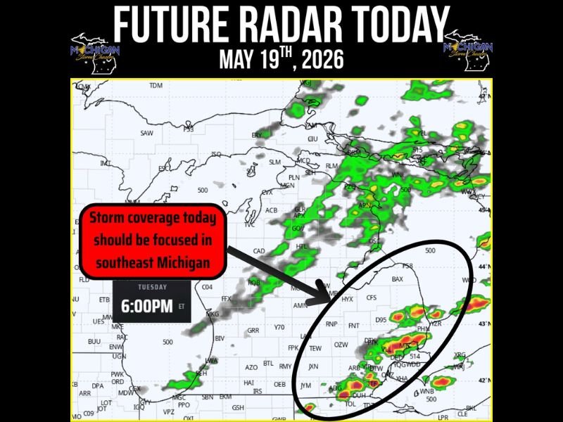
Southeast Michigan Sees Best Storm Coverage Between Mid Afternoon and Early Evening
Future radar valid at 6 PM Tuesday shows storm activity concentrated across the southeast Michigan corridor near Detroit, with the heaviest cells clustered in that zone during the peak coverage window. The mid afternoon to early evening timeframe represents the highest risk period for communities across southeast Michigan today.
Storms developing in this environment will be driven by cold front forcing and atmospheric instability combining to produce organized and potentially severe thunderstorms.
Damaging Winds to 60mph and 1 Inch Hail Possible With Any Storm Today
Any storm managing to reach severe criteria across Michigan today carries the potential for wind gusts up to 60 mph and hail up to 1 inch in diameter. These hazards can cause significant damage to vehicles, property, and trees across any community directly in the path of a severe-warned storm.
Residents across southeast Michigan and the Detroit area should have weather alerts active and be ready to move indoors quickly during the mid afternoon hours today.
Tornado Risk Low But Storm Interactions Could Locally Enhance Shear
Tornado potential is currently assessed as very low for today’s Michigan storm setup, but forecasters are monitoring storm-storm interactions and surface boundaries that could locally enhance wind shear and create a brief isolated tornado opportunity. While not a primary concern, tornado awareness should remain part of today’s weather preparedness across the region.
Storms are also possible further west across Michigan as the cold front continues pushing through the state through the afternoon and evening hours. Stay with NapervilleLocal.com for the latest weather updates and local forecast coverage.

I’ve lived in Naperville long enough to see how quickly our community changes — from new developments downtown to sudden shifts in our Midwest weather. Reporting on Naperville news and daily forecasts gives me the chance to keep neighbors informed about what really matters. My goal is simple: deliver clear, timely updates so you always know what’s happening in our city and what to expect from the skies above.