
Surprise Storm Complex Bringing Heavy Rain and Flooding Threat Across Houston Conroe Beaumont and Galveston With Weather Watch in Effect Through Tonight
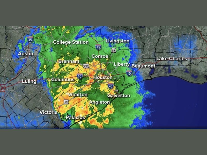
HOUSTON — A surprise storm complex is blowing through the Houston coastal counties Tuesday morning, sending heavy rain showers well north of the city and creating a challenging and difficult-to-predict weather pattern through the area. Radar at 6:40 AM shows intense yellow and orange returns blanketing the greater Houston metro from Columbus and Brenham through Conroe, Liberty, Galveston, and Beaumont.
Surprise Storm Complex Covers Houston Metro With Heavy Rain at 640AM
The storm complex currently pushing through Houston and surrounding coastal counties was not well anticipated, highlighting the challenging nature of the current active jet pattern overhead. Heavy rainfall is occurring across a wide area from Wharton and Palacios northward through Houston, Conroe, and toward College Station and Livingston as of early Tuesday morning.
Flooding is a primary concern given the heavy rainfall rates currently being recorded across the greater Houston metro corridor.
Flooding Threat Elevated Across Coastal Counties With Weather Watch Through Tonight
The ABC13 Alert Radar is showing both severe and flooding indicators across the Houston coastal county corridor, with the heaviest activity concentrated around the Houston metro through Beaumont and Galveston. The Weather Watch remaining in effect through tonight means additional rounds of heavy rainfall and storm activity are expected beyond this morning’s surprise complex.
Residents across Harris, Galveston, Liberty, and surrounding coastal counties should monitor conditions closely and avoid any flood-prone roadways through the day.
Active Pattern Remains Challenging Through Memorial Day Requiring Constant Weather Awareness
The current active jet pattern overhead is creating difficult-to-time weather disturbances that are challenging even experienced forecasters to predict with precision. Residents across the greater Houston area should remain weather aware continuously through Memorial Day as surprise storm complexes like this morning’s event remain possible on any given day within this pattern.
Monitoring real-time radar and keeping weather alerts active is the most important step for anyone across Southeast Texas through the extended active stretch.
Stay with NapervilleLocal.com for the latest weather updates and local forecast coverage.

I’ve lived in Naperville long enough to see how quickly our community changes — from new developments downtown to sudden shifts in our Midwest weather. Reporting on Naperville news and daily forecasts gives me the chance to keep neighbors informed about what really matters. My goal is simple: deliver clear, timely updates so you always know what’s happening in our city and what to expect from the skies above.