
Warm Humid Friday With Scattered Spotty Showers and Storms Across Arkansas Including Little Rock, Fort Smith, and Texarkana With Highs Reaching the Upper 70s to Upper 80s
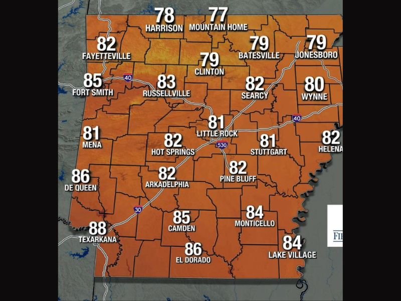
ARKANSAS — A warm, humid, and unsettled Friday is in store across Arkansas with scattered and spotty showers and storms possible throughout the day on a hit or miss basis, meaning some communities will stay completely dry while others see brief rainfall. High temperatures will range from the upper 70s in the north to the upper 80s across southern Arkansas, with the humidity making conditions feel noticeably more uncomfortable across the entire state. More rain and storm chances return again Saturday, keeping the unsettled pattern going through the weekend.
Statewide Highs Climbing From Upper 70s in the North to Upper 80s Across the South
Northern Arkansas will see the coolest readings of the day with Harrison at 78 degrees and Mountain Home at 77, while Fayetteville reaches 82 and Batesville and Jonesboro both top out at 79. The central corridor sits firmly in the low 80s with Little Rock at 81, Russellville at 83, and Hot Springs reaching 82 degrees through the afternoon.
Southern Arkansas will be the warmest zone on Friday with Texarkana leading the state at 88 degrees, El Dorado reaching 86, De Queen at 86, and Camden climbing to 85. Lake Village and Monticello will both reach the mid 80s, making the southwest and southeast corners of the state the most oppressively warm and humid zones through the afternoon.
Scattered Spotty Showers and Storms Possible Throughout the Day on a Hit or Miss Basis
The storm coverage on Friday will be scattered and spotty in nature, meaning radar will show activity across the state but individual communities face an uneven chance of actually seeing rainfall. Some areas will pick up brief downpours while neighbors just miles away remain dry through the entire day.
The hit or miss pattern makes precise rainfall prediction difficult, but anyone across Arkansas should keep an eye on developing radar activity through the afternoon and evening hours.
More Rain and Storm Chances Return Saturday Extending the Unsettled Pattern
Friday’s scattered activity is just the continuation of an ongoing unsettled stretch, with more rain and storm chances already in the forecast for Saturday across Arkansas. Residents should plan for another active weather day heading into the weekend and stay connected to local forecast updates. Stay with NapervilleLocal.com for the latest weather updates and local forecast coverage.

I’ve lived in Naperville long enough to see how quickly our community changes — from new developments downtown to sudden shifts in our Midwest weather. Reporting on Naperville news and daily forecasts gives me the chance to keep neighbors informed about what really matters. My goal is simple: deliver clear, timely updates so you always know what’s happening in our city and what to expect from the skies above.