
Drought Improvements Recorded Across North Carolina With D4 Removed From Foothills but Extreme D3 Conditions Persisting Across the Piedmont Including Greensboro and Raleigh
NORTH CAROLINA — Meaningful drought improvements have been recorded across much of North Carolina in the latest drought status report valid Thursday, May 28, 2026, with the worst D4 exceptional drought category completely removed from the Foothills and mountain zones reduced from their prior levels.
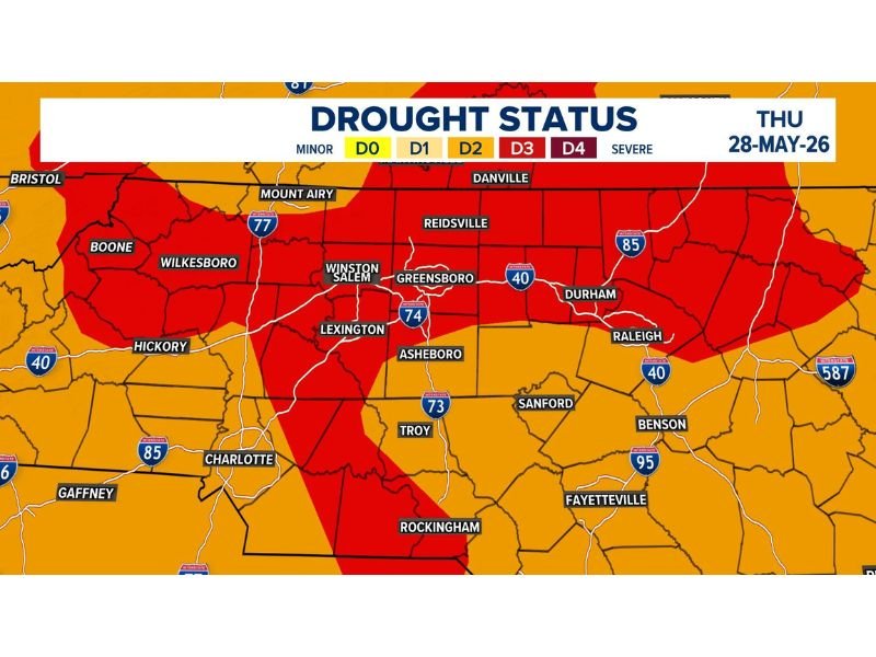
However, extreme D3 drought conditions continue to persist across much of the Piedmont corridor including Greensboro, Winston-Salem, Raleigh, and Durham, and forecasters note that this week’s report does not yet account for the heavy rainfall that fell Tuesday and Wednesday, meaning actual conditions are likely somewhat better than currently depicted.
D4 Exceptional Drought Removed From Foothills as Mountains Improve to D2
The complete removal of the D4 exceptional drought designation from the Foothills represents a significant first step in addressing the long-term moisture deficit across western North Carolina. Mountain zones have been reduced to D2 moderate to severe drought conditions, reflecting meaningful improvement from prior weeks driven by recent rainfall events across the higher terrain.
These improvements mark a positive turning point for communities in the Foothills and mountain zones that had been enduring the most extreme drought conditions recorded in the state. However, forecasters are clear that a single wet period is only the first step in addressing what remains a serious and long-term moisture deficit across the region.
Extreme D3 Drought Persists Across the Piedmont From Winston-Salem Through Raleigh
The broad Piedmont corridor from Winston-Salem and Greensboro through Asheboro, Durham, and Raleigh remains locked in D3 extreme drought conditions as of Thursday’s report. The deep red D3 signature covers a wide geographic zone across central North Carolina, indicating that significant moisture recovery work remains ahead for the most populated areas of the state.
Surrounding D2 and D1 conditions visible across portions of the Charlotte area, Hickory, and the southern zones show a gradual improvement gradient but confirm that drought impacts remain widespread statewide.
Recent Heavy Rain Not Yet Reflected With Further Improvements Expected Next Week
Tuesday and Wednesday’s heavy rainfall across the region has not yet been incorporated into this week’s drought status report due to data collection timelines. Next week’s report is expected to reflect additional improvement across multiple drought categories as that rainfall data is processed, giving North Carolina residents reason for cautious optimism heading into June. Stay with NapervilleLocal.com for the latest weather updates and local forecast coverage.

I’ve lived in Naperville long enough to see how quickly our community changes — from new developments downtown to sudden shifts in our Midwest weather. Reporting on Naperville news and daily forecasts gives me the chance to keep neighbors informed about what really matters. My goal is simple: deliver clear, timely updates so you always know what’s happening in our city and what to expect from the skies above.