
Flash Flood Risk With Isolated Heavy Downpours Targeting the Gulf Coast and Southeast Including Alabama, Georgia, and Florida With Slight Risk Through Monday June 1
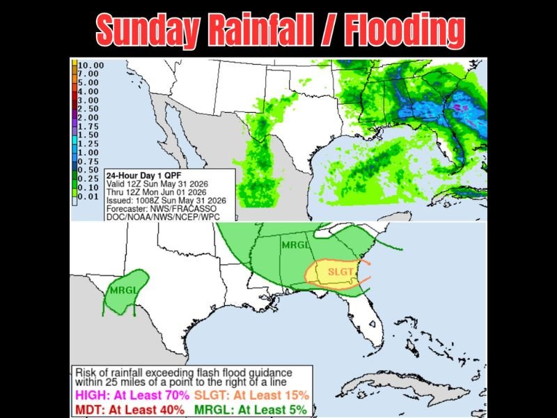
GULF COAST AND SOUTHEAST — A flash flood risk is active across the Gulf Coast and Southeast on Sunday, May 31 through Monday, June 1, 2026, as the 24-hour Day 1 QPF valid 12Z Sunday through 12Z Monday shows a west to east rainfall flow pattern bringing isolated but potentially heavy downpours across the region. The event is not an all-day rain scenario but rather isolated potentials for large amounts falling fast, with flooding chances elevated across the yellow Slight risk zone covering Alabama, Georgia, and the Florida Panhandle where flash flood guidance could be exceeded.
Slight Flash Flood Risk Zone Covers Alabama, Georgia, and Florida Panhandle Corridor
The Slight flash flood risk designation covering the Alabama, Georgia, and Florida Panhandle corridor indicates at least a 15 percent probability of rainfall exceeding flash flood guidance within 25 miles of any point in the zone. This elevated risk reflects the combination of heavy isolated rain rates possible with individual storm cells and already-saturated ground across portions of the region from recent rainfall events.
The broader Marginal risk zone extends the flash flood concern westward across the Gulf Coast states through Louisiana and into central Texas, where isolated heavy downpours also carry at least a 5 percent probability of exceeding flash flood thresholds through the period.
West to East Flow Pattern Driving Isolated Heavy Downpour Potential Sunday
The QPF map shows a west to east rainfall flow pattern with green coverage stretching from Texas eastward through the Gulf Coast states and into the Carolinas and Florida. The heaviest potential rainfall signatures are concentrated across the Alabama, Georgia, and Florida corridor where the blue and teal values on the QPF scale indicate the highest projected accumulations.
While the coverage will not be widespread throughout the day, any location that does fall under an active storm cell could see a significant amount of rain in a short period.
Flooding Risk Most Elevated Where Heaviest Rain Falls on Already Saturated Ground
Residents across the Slight and Marginal risk zones should remain weather aware through Sunday and be prepared for rapidly developing localized flooding wherever the heaviest rain concentrates. Avoiding flooded roadways and monitoring local flash flood warnings throughout the day remains the most critical safety action for the region.
Stay with NapervilleLocal.com for the latest weather updates and local forecast coverage.

I’ve lived in Naperville long enough to see how quickly our community changes — from new developments downtown to sudden shifts in our Midwest weather. Reporting on Naperville news and daily forecasts gives me the chance to keep neighbors informed about what really matters. My goal is simple: deliver clear, timely updates so you always know what’s happening in our city and what to expect from the skies above.