
Damaging Wind Gusts Up to 60 MPH and Torrential Rain Targeting North Alabama Including Birmingham and Huntsville Monday Afternoon Into Monday Evening
NORTH ALABAMA — A dangerous line of summer storms is expected to push into North Alabama Monday afternoon and continue developing through the evening hours, bringing damaging wind gusts, torrential rainfall, and intense lightning to the region. A very hot and humid air mass is fueling the incoming storm line, which forecasters describe as a classic summer wind machine capable of widespread tree damage. Soggy ground conditions across the area will make trees significantly more vulnerable to toppling even with moderate wind gusts.
Storm Line Arrives Into North Alabama by Early Monday Afternoon
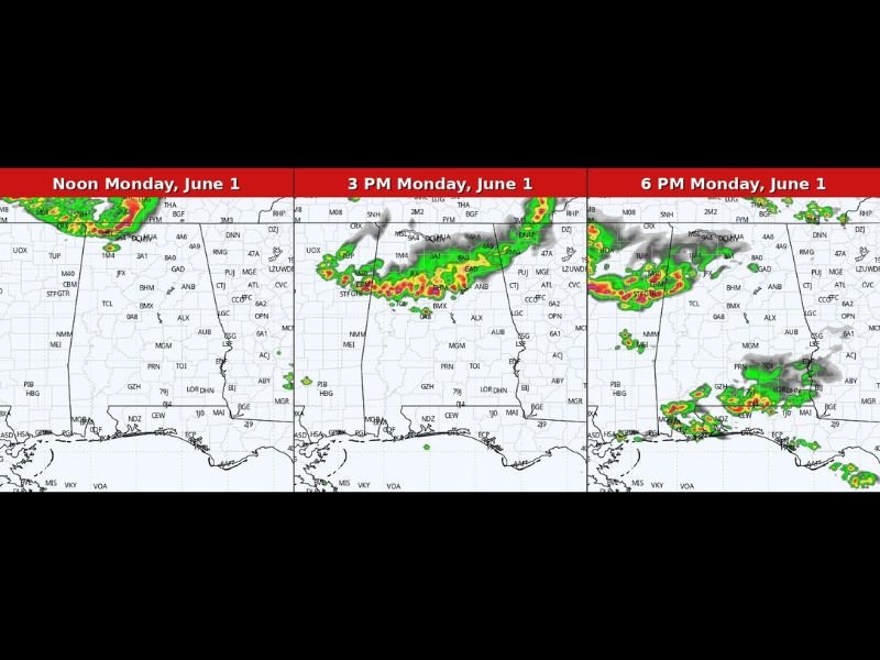
Forecast radar imagery shows a wave of storms pushing into North Alabama by noon to early afternoon Monday, with the line intensifying and expanding through the 3 PM timeframe. The storm system is tracking southward from the north, driven by the unstable hot and humid air mass already in place across the state. Confidence is increasing that the timing will bring the most significant activity during the Monday afternoon commute window.
Wind Gusts 35 to 60 MPH the Primary Threat Along the Storm Line
The main hazard with this system is damaging straight-line winds, with gusts expected between 35 and 50 mph broadly along the line and isolated higher gusts upwards of 60 mph possible in the strongest cells. These wind speeds are sufficient to bring down trees and power lines, particularly given how saturated the ground currently is across the region. Residents should move outdoor furniture and loose objects inside before Monday afternoon.
Additional Storm Development Continues Through Monday Evening Hours
The 6 PM forecast panel shows storm activity persisting and additional cells developing across central and southern portions of the state through the evening. Locally heavy downpours and intense lightning will accompany the wind threat throughout the event. Anyone with outdoor plans Monday afternoon and evening should build in a weather safety component and monitor conditions closely as the storm line approaches. Stay with NapervilleLocal.com for the latest weather updates and local forecast coverage.

I’ve lived in Naperville long enough to see how quickly our community changes — from new developments downtown to sudden shifts in our Midwest weather. Reporting on Naperville news and daily forecasts gives me the chance to keep neighbors informed about what really matters. My goal is simple: deliver clear, timely updates so you always know what’s happening in our city and what to expect from the skies above.