
Very Large Hail Over 2 Inches Damaging Winds and Brief Tornado Threat Targeting Colorado Wyoming Nebraska and Kansas With Supercells Initiating Monday June 1
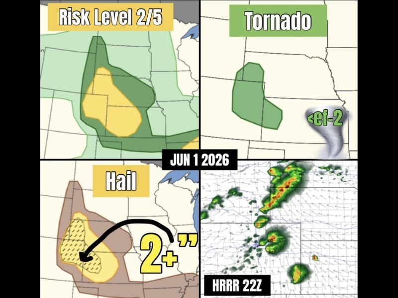
COLORADO AND WYOMING — A severe weather setup is underway across the front ranges of Colorado and Wyoming Monday June 1, with supercell development expected to bring very large hail, damaging winds, and a brief tornado threat to a broad corridor stretching into Nebraska and Kansas. The overall risk is rated at Level 2 out of 5, with the yellow enhanced zone covering portions of Colorado, Wyoming, and western Nebraska indicating the highest concentration of hazards. Storms are expected to grow upscale as they push northeast, transitioning into a high-based wind-dominant threat across the plains.
Supercell Initiation Along Colorado and Wyoming Front Range the Starting Point
Storm initiation is focused along the front ranges of Colorado and Wyoming, where atmospheric instability is sufficient to support discrete supercell development. These initial supercells carry the highest potential for very large hail and carry a non-zero tornado threat, with any tornadoes expected to remain below EF-2 intensity based on current outlook parameters. The HRRR 22Z model is already depicting organized convective clusters tracking northeast out of the initiation zone.
Hail Over 2 Inches the Primary Threat Across the Yellow Risk Zone
The hail threat map shows a hatched zone within the yellow area indicating the potential for hail exceeding 2 inches in diameter across portions of Colorado and into western Nebraska. Hail of this size is capable of causing significant damage to vehicles, rooftops, crops, and any property left exposed outdoors. Residents within the yellow zone should have a plan to shelter vehicles and avoid travel during active storm periods this afternoon and evening.
Storms Grow Upscale Into Wind Makers Pushing Into Nebraska and Kansas
As the storm clusters push into Nebraska and Kansas through the afternoon and evening, upscale growth into a more linear wind-producing system becomes increasingly likely. Wind gusts of 75 mph or higher are possible even though the current official outlook does not fully reflect that potential. Anyone across western Nebraska and northwestern Kansas should monitor conditions closely as the line pushes through during the evening hours. Stay with NapervilleLocal.com for the latest weather updates and local forecast coverage.

I’ve lived in Naperville long enough to see how quickly our community changes — from new developments downtown to sudden shifts in our Midwest weather. Reporting on Naperville news and daily forecasts gives me the chance to keep neighbors informed about what really matters. My goal is simple: deliver clear, timely updates so you always know what’s happening in our city and what to expect from the skies above.