
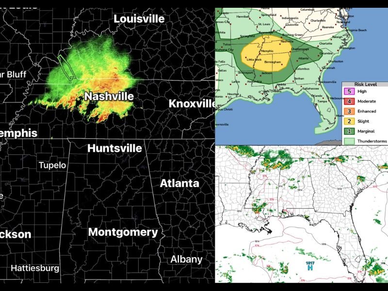
Damaging Wind Gusts and Squall Line Targeting North Georgia and Alabama Including Atlanta Birmingham and Huntsville Monday Afternoon Into Evening
NORTH GEORGIA AND ALABAMA — A squall line is expected to approach north Georgia as early as 1 to 2 PM Monday before pushing southward through the afternoon and evening, with the NWS and local forecasters expecting the thunderstorm complex to track more heavily into Alabama due to favorable atmospheric parameters and the influence of a wedge remaining across the Carolinas.
North Georgia carries a Marginal Risk for strong to damaging wind gusts with the initial push of the squall line, while Alabama sits within a broader Slight Risk zone on the regional outlook. Areas across north Georgia that have received significant rainfall this past week face elevated tree damage potential due to saturated and loosened soils.
Squall Line Arrives North Georgia Between 1 and 2 PM Monday Afternoon
The leading edge of the squall line is forecast to reach north Georgia between 1 and 2 PM, bringing the primary window for damaging wind gusts with the first initial push through the region. Radar is already showing an intense MCS complex near the Nashville and Louisville corridor tracking southward with red and orange returns indicating a strong and organized system. The Marginal Risk designation for north Georgia reflects the damaging wind threat as the line makes its initial entry into the state during the early afternoon.
MCS Expected to Favor Alabama With Better Parameters Pulling System Southwest
Better atmospheric parameters across Alabama combined with the Carolinas wedge influence are expected to pull the bulk of the MCS energy southwest into Alabama rather than deeper into Georgia. Birmingham, Huntsville, and surrounding communities sit within the yellow Slight Risk zone on the outlook map, indicating a more concentrated severe weather threat than what north Georgia faces. The squall line could produce widespread damaging winds across central and northern Alabama as it pushes through during the afternoon and evening hours.
MCS Likely Fizzles Before Reaching Metro Atlanta With Isolated Shower Chance Near Macon
As the squall line loses energy tracking southward, forecasters expect the complex to weaken significantly before reaching the Atlanta metro area. A low-end scenario exists where isolated showers and thunderstorms push as far south as the Macon area near 10 PM, but widespread severe weather reaching central Georgia appears unlikely. Saturated soils across north Georgia remain a concern for tree damage even with lower-end wind gusts along the initial line passage. Stay with NapervilleLocal.com for the latest weather updates and local forecast coverage.

I’ve lived in Naperville long enough to see how quickly our community changes — from new developments downtown to sudden shifts in our Midwest weather. Reporting on Naperville news and daily forecasts gives me the chance to keep neighbors informed about what really matters. My goal is simple: deliver clear, timely updates so you always know what’s happening in our city and what to expect from the skies above.