
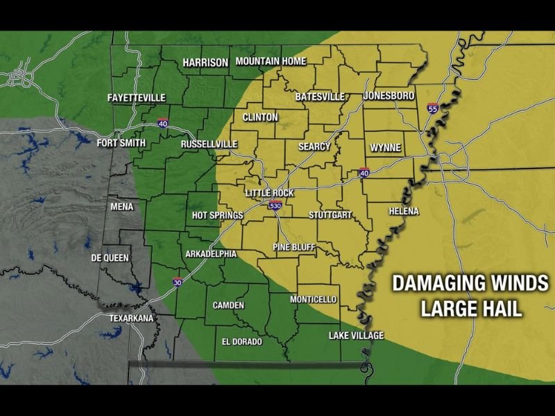
Damaging Winds and Large Hail Targeting Eastern Arkansas Including Little Rock Jonesboro and Searcy With Severe Storms Drifting South Monday Evening
ARKANSAS — Severe weather is possible across Arkansas later Monday evening, with the best chances concentrated across the eastern half of the state where a yellow severe outlook zone covers a large swath of communities including Little Rock, Jonesboro, Searcy, Wynne, and Helena. Storms are expected to form across north Arkansas and southern Missouri during the late afternoon before drifting southward through the evening hours. Coverage of widespread storm activity is significantly higher today compared to yesterday, raising the threat level for impacted communities.
Storms Form Across North Arkansas and Southern Missouri Late Afternoon
Initial storm development is forecast across north Arkansas and the southern Missouri border during the late afternoon hours, with activity then tracking southward into the heart of the state through the evening. Cities including Harrison, Mountain Home, Batesville, and Clinton sit near the northern edge of the yellow risk zone and should expect early storm impacts. The southward drift will push activity through central Arkansas and into southern portions of the state as the night progresses.
Damaging Winds and Large Hail the Primary Hazards Across the Yellow Zone
The Arkansas Weather Network severe outlook identifies damaging winds and large hail as the two primary threats associated with this evening’s storm activity. The yellow zone encompasses a broad area covering central and eastern Arkansas, with communities from Searcy and Clinton down through Pine Bluff, Stuttgart, and Monticello all within the elevated risk footprint. Western Arkansas including Fort Smith, Fayetteville, and Texarkana sit within the lower green zone and carry a reduced but non-zero severe weather threat.
Tornado Risk Very Low but Eastern Half Needs to Stay Alert This Evening
The tornado risk is considered very low with this setup, keeping the focus squarely on wind and hail hazards as storms move through. Residents across the eastern half of Arkansas should monitor conditions closely through the evening hours and have a way to receive warnings. Anyone with outdoor plans Monday evening across the yellow zone should build in flexibility as storms approach from the north. Stay with NapervilleLocal.com for the latest weather updates and local forecast coverage.

I’ve lived in Naperville long enough to see how quickly our community changes — from new developments downtown to sudden shifts in our Midwest weather. Reporting on Naperville news and daily forecasts gives me the chance to keep neighbors informed about what really matters. My goal is simple: deliver clear, timely updates so you always know what’s happening in our city and what to expect from the skies above.