
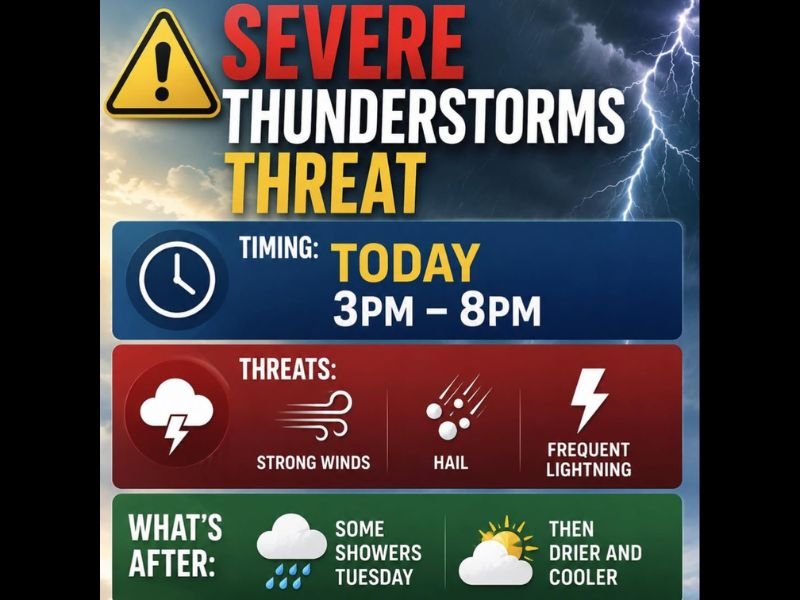
Strong Winds Hail and Frequent Lightning Possible With Severe Thunderstorms This Afternoon and Evening Between 3 PM and 8 PM Monday
LOCAL AREA — Strong to severe thunderstorms are possible this afternoon and evening, with the greatest risk window running from 3 PM through 8 PM as an upper-level disturbance moves through the region. Not every location will see storm development, but any storms that do fire could produce strong winds, hail, and frequent lightning in a short period of time. Residents should have a plan in place before the afternoon hours arrive and monitor conditions closely as the threat window opens.
Greatest Severe Risk Concentrated Between 3 PM and 8 PM This Afternoon
The primary threat window is tightly defined between 3 PM and 8 PM today, driven by an upper-level disturbance tracking through the area during the peak heating hours of the afternoon. This timing coincides directly with the afternoon commute, meaning anyone traveling between those hours should stay aware of rapidly changing conditions. Storms could develop quickly and produce hazardous conditions with limited warning time in the most intense cells.
Strong Winds Hail and Frequent Lightning the Three Headline Threats
The three confirmed hazards associated with any severe storms that develop are strong winds, hail, and frequent lightning. Strong winds pose a threat to trees, power lines, and unsecured outdoor objects, while hail could cause damage to vehicles and property depending on stone size. Frequent lightning will make any outdoor activity dangerous during the active storm period and anyone caught outside should seek sturdy shelter immediately when storms approach.
Cooler and Drier Air Returns for Midweek After Tuesday Showers Clear
The severe weather threat is a one-day event, with conditions improving fairly quickly after the system pushes through. A few lingering showers are expected Tuesday before cooler and drier air moves into the region for the middle of the week. Anyone with outdoor plans later in the week can expect a much more comfortable and storm-free pattern to settle in following Tuesday’s residual shower activity. Stay with NapervilleLocal.com for the latest weather updates and local forecast coverage.

I’ve lived in Naperville long enough to see how quickly our community changes — from new developments downtown to sudden shifts in our Midwest weather. Reporting on Naperville news and daily forecasts gives me the chance to keep neighbors informed about what really matters. My goal is simple: deliver clear, timely updates so you always know what’s happening in our city and what to expect from the skies above.