
Rare June Cold Front Bringing Gusty Winds Hail and Lightning to Florida’s Nature Coast Including Crystal River Brooksville and Chiefland Tuesday Evening Into Overnight
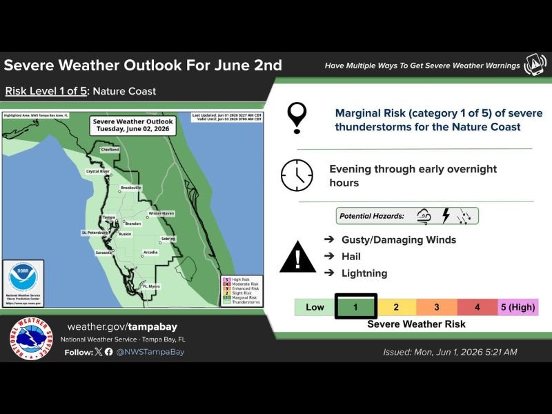
FLORIDA NATURE COAST — An unusual June cold front is set to push through Florida’s Nature Coast later Tuesday and into Wednesday, bringing a Marginal Risk Level 1 of 5 severe weather threat to communities including Crystal River, Brooksville, Chiefland, and surrounding areas during the evening through early overnight hours.
The National Weather Service Tampa Bay issued the outlook Monday morning, identifying gusty and damaging winds, hail, and lightning as the potential hazards tied to the frontal passage. Rain chances will increase broadly as the front moves through, with a few stronger storms possible along the leading edge.
Marginal Risk Level 1 of 5 Covers the Nature Coast for Tuesday Evening
The NWS Tampa Bay severe weather outlook places the Nature Coast under a Marginal Risk category for Tuesday June 2nd, with the threat window opening during the evening hours and continuing into the early overnight. The risk zone on the outlook map hugs the western Florida coastline from Chiefland southward through Crystal River, Brooksville, and the greater Tampa Bay area including Brandon, Ruskin, and Sarasota. Communities along this coastal corridor should monitor evening forecasts and have a way to receive warnings as the front approaches.
Gusty Damaging Winds Hail and Lightning the Three Identified Hazards
The NWS has flagged three specific hazards for the Tuesday evening event including gusty and damaging winds, hail, and lightning associated with any storms that develop along the frontal boundary. While the overall risk remains low at category 1, individual storms along the front can still produce brief but impactful hazards in a short timeframe. Outdoor evening plans across the Nature Coast should include a weather contingency given the timing of the threat.
Cooler and Less Humid Pattern Arrives North of I-4 Later in the Week
Following the frontal passage, lower humidity and cooler morning temperatures will settle in across areas north of Interstate 4 later in the week. Afternoon high temperatures will also drop noticeably compared to the oppressive heat felt earlier this week. The brief severe threat Tuesday evening is the trade-off for a significantly more comfortable midweek pattern across the region. Stay with NapervilleLocal.com for the latest weather updates and local forecast coverage.

I’ve lived in Naperville long enough to see how quickly our community changes — from new developments downtown to sudden shifts in our Midwest weather. Reporting on Naperville news and daily forecasts gives me the chance to keep neighbors informed about what really matters. My goal is simple: deliver clear, timely updates so you always know what’s happening in our city and what to expect from the skies above.