
Rare Day 4 Elevated Severe Weather Risk Targeting Minnesota Iowa and Wisconsin Including Minneapolis Sioux Falls and Madison Wednesday June 10th
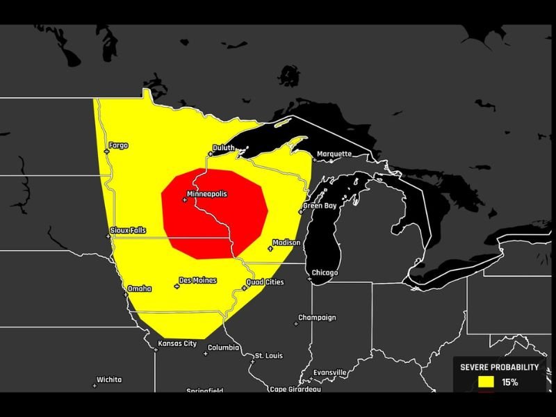
MINNESOTA, IOWA AND WISCONSIN — A rare Day 4 elevated severe weather risk is now on the map for Wednesday June 10th across Minnesota, Iowa, and Wisconsin, with the SPC probabilistic outlook updated Sunday June 7th showing a 30 percent severe probability zone centered directly over Minneapolis and extending through the Sioux Falls and Madison corridor. A broader 15 percent severe probability zone surrounds the inner red circle, covering a large footprint from Fargo and Duluth southward through Des Moines, the Quad Cities, and toward Kansas City.
A Day 4 elevated risk designation from the SPC is considered rare and signals unusually high forecaster confidence for an event still several days away.
30 Percent Severe Probability Zone Bullseye Centers Over Minneapolis
The deep red 30 percent severe probability zone is tightly concentrated over the Minneapolis metro area and extends southward through Wisconsin toward Madison and Green Bay, and westward toward Sioux Falls. This level of Day 4 confidence is uncommon and reflects a well-defined atmospheric setup that forecasters can already identify with significant clarity several days in advance.
Communities directly within the red zone should begin making early awareness preparations and monitor forecast updates daily through Wednesday.
Broader 15 Percent Zone Covers Fargo Des Moines Quad Cities and Omaha
The wider yellow 15 percent severe probability zone encompasses a very large portion of the upper Midwest, stretching from Fargo and Duluth in the north southward through Omaha, Des Moines, the Quad Cities, and curving eastward toward Chicago and Green Bay. This broad coverage means a very large number of communities across multiple states carry at least a meaningful severe weather threat for Wednesday.
The specific hazards associated with this setup will become clearer as the event approaches and higher-resolution model data becomes available.
Monitor Daily Forecast Updates Through Wednesday as Confidence Builds
With the event still several days away, specific details regarding storm timing, hazard types, and highest-risk corridors will continue to be refined with each model run through Tuesday. Residents across Minnesota, Iowa, and Wisconsin from Fargo through Minneapolis, Sioux Falls, Des Moines, and Madison should treat Wednesday as a weather-aware day and stay closely connected to local forecast updates.
Stay with NapervilleLocal.com for the latest weather updates and local forecast coverage.

I’ve lived in Naperville long enough to see how quickly our community changes — from new developments downtown to sudden shifts in our Midwest weather. Reporting on Naperville news and daily forecasts gives me the chance to keep neighbors informed about what really matters. My goal is simple: deliver clear, timely updates so you always know what’s happening in our city and what to expect from the skies above.