
Wind Gusts Exceeding 75 MPH and Very Large Hail Targeting North and South Dakota Including Bismarck Rapid City and Fargo With Enhanced Risk Level 3 Today
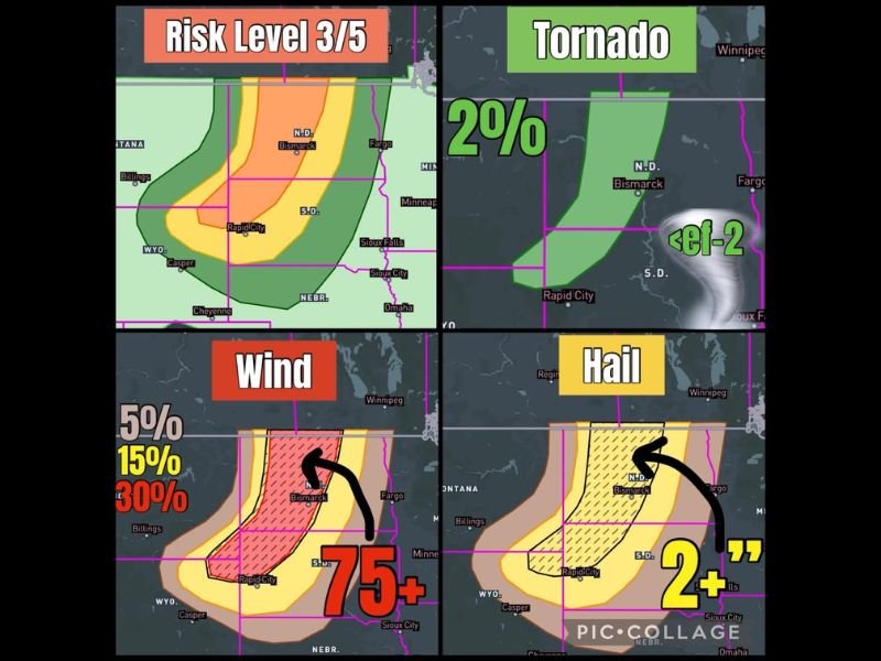
NORTH AND SOUTH DAKOTA — An Enhanced severe weather event is underway across North and South Dakota today as a powerful squall line brings widespread damaging winds, very large hail, and a brief tornado threat to the region under a Risk Level 3 of 5 designation. Wind gusts exceeding 75 mph are the primary and most dangerous threat, with a 30 percent wind probability hatched zone centered over the Bismarck and Rapid City corridor indicating where the most destructive gusts are most likely to occur.
The synoptic pattern strongly favors wind as the dominant storm mode, with damaging straight-line gusts capable of causing widespread structural damage across both states.
75 Plus MPH Wind Gusts the Dominant Threat Across the Hatched Zone
The wind probability map shows a red 30 percent hatched zone centered over the central Dakotas from Bismarck southward through Rapid City, indicating significant confidence in wind gusts exceeding 75 mph across this corridor. Surrounding yellow 15 percent and tan 5 percent wind probability zones extend the damaging wind threat broadly across both states and into portions of Nebraska and Wyoming.
Wind gusts at this magnitude are capable of causing widespread tree and power line damage, roof damage to structures, and making travel extremely hazardous.
Very Large Hail Over 2 Inches Possible in Early Cellular Storm Modes
Before the squall line consolidates and becomes wind-dominant, early discrete cellular storm modes will carry the potential for very large hail exceeding 2 inches in diameter across the hatched hail zone covering the central Dakotas. The hail threat is concentrated in the same general corridor as the wind threat, running from Bismarck southward through the Rapid City area.
Residents should secure vehicles under cover before storms develop during the early storm initiation period.
Brief Tornado Cannot Be Ruled Out From QLCS Circulations
A two percent tornado probability exists across the risk zone, with any tornadoes expected below EF-2 intensity and dependent on storm interactions or QLCS circulations embedded within the squall line. The tornado threat is secondary to the dominant wind hazard but cannot be dismissed entirely.
Have multiple ways to receive warnings active throughout the day across both states. Stay with NapervilleLocal.com for the latest weather updates and local forecast coverage.

I’ve lived in Naperville long enough to see how quickly our community changes — from new developments downtown to sudden shifts in our Midwest weather. Reporting on Naperville news and daily forecasts gives me the chance to keep neighbors informed about what really matters. My goal is simple: deliver clear, timely updates so you always know what’s happening in our city and what to expect from the skies above.