
Dangerous Heat Peaking Near 100 Degrees Across Colorado Including Denver Front Range Eastern Plains and Western Slope Tuesday Through Wednesday
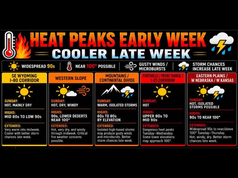
COLORADO AND SURROUNDING REGION — A dangerous early-week heat event is building across Colorado and the surrounding region Sunday June 7th, with widespread 90s already in place today before temperatures peak even higher Tuesday through Wednesday. The eastern plains into western Nebraska and western Kansas face the most extreme readings with highs reaching 90s to near 100 degrees through midweek, while the Front Range and I-25 corridor sees dangerous heat peaking Tuesday through Wednesday with some lower elevations approaching 100 degrees.
Relief arrives late week as the ridge weakens and storm chances increase, but the next several days demand serious heat safety awareness.
Front Range and Eastern Plains Face Dangerous Peak Heat Tuesday Through Wednesday
The Foothills, Front Range, and I-25 corridor will see upper 80s to mid 90s Sunday before dangerous heat peaks Tuesday and Wednesday with lower elevations potentially approaching 100 degrees. The eastern plains into western Nebraska and western Kansas climb to 90s to near or above 100 degrees Tuesday through Thursday under hot, windy, and dry conditions.
These are not comfortable dry heat readings but genuinely dangerous temperatures that pose serious heat exhaustion and heat stroke risks for outdoor exposure.
Western Slope Hits the 90s With Lower Deserts Near 100 and Critical Fire Danger
The western slope reaches the 90s Sunday with lower desert locations approaching 100 degrees, and conditions remain hot, very dry, and windy through midweek. Critical fire weather concerns are possible at times across the western slope through the peak heat period as the combination of extreme heat, low humidity, and gusty winds creates dangerous fire weather conditions.
SE Wyoming and the I-80 corridor reach mid 80s to low 90s Sunday before warming further into midweek.
High-Based Storms Bring Gusty Microburst Winds With Little to No Rainfall
Isolated high-based afternoon storms over the mountains and foothills will produce more wind than water, with strong outflow winds and localized microbursts possible while delivering little to no rainfall at the surface. Stay hydrated, wear sunscreen, never leave children or pets in vehicles, and exercise extreme caution near lakes and reservoirs where water temperatures remain dangerously cold despite the extreme air temperatures. Stay with NapervilleLocal.com for the latest weather updates and local forecast coverage.

I’ve lived in Naperville long enough to see how quickly our community changes — from new developments downtown to sudden shifts in our Midwest weather. Reporting on Naperville news and daily forecasts gives me the chance to keep neighbors informed about what really matters. My goal is simple: deliver clear, timely updates so you always know what’s happening in our city and what to expect from the skies above.