
Scattered Storms Heavy Rain and Very Low Tornado Chance Across Arkansas Including Little Rock Fayetteville Fort Smith and Hot Springs Sunday Afternoon
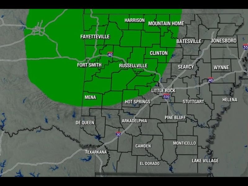
ARKANSAS — Scattered storms are likely across Arkansas Sunday afternoon with activity expected on and off throughout the day, bringing heavy rain and a very low severe weather risk to a large portion of the state. The Arkansas Weather Network tornado risk map shows a green very low risk zone covering the western half of Arkansas from Fayetteville and Fort Smith southward through Mena, De Queen, and Texarkana, with the tornado chance remaining low but non-zero similar to Saturday’s setup.
Forecasters will be watching radar closely through the afternoon but stress this is not something that should cause significant concern for most residents.
Rain Chances of 80 to 90 Percent Across Much of the State Sunday
The rain probability map shows very high rain chances of 80 to 90 percent blanketing most of Arkansas Sunday, with the highest coverage across the northern and central portions of the state including Harrison, Mountain Home, Batesville, Clinton, Little Rock, and Hot Springs all at 80 to 90 percent. Southern communities including Texarkana and El Dorado sit at 60 to 70 percent, still carrying a solid chance for afternoon shower activity.
The futurecast valid Sunday at 4 PM shows widespread green returns across the state with pockets of yellow, orange, and red indicating locally heavier rainfall embedded within the broader coverage.
Very Low Tornado Risk Exists Across Western Arkansas Similar to Saturday
The tornado risk map designates the western half of Arkansas in the green very low category, with forecasters noting that just like Saturday there remains a chance for a tornado or two somewhere across the state during the afternoon storm activity. The risk is not elevated enough to cause alarm but is sufficient to warrant weather awareness and having alerts enabled.
Eastern Arkansas communities from Jonesboro through Wynne, Helena, and Lake Village sit outside the formal tornado risk zone but will still see heavy rain and storm activity through the afternoon.
Storms On and Off Throughout the Afternoon With Heavy Rain the Main Concern
The primary impact for most Arkansans today will be the repeated rounds of heavy rainfall rather than any severe weather component. Flooding of low-lying areas and poor drainage locations is possible with 80 to 90 percent rain coverage and multiple rounds of storms tracking through. Stay weather aware and monitor radar through Sunday evening. Stay with NapervilleLocal.com for the latest weather updates and local forecast coverage.

I’ve lived in Naperville long enough to see how quickly our community changes — from new developments downtown to sudden shifts in our Midwest weather. Reporting on Naperville news and daily forecasts gives me the chance to keep neighbors informed about what really matters. My goal is simple: deliver clear, timely updates so you always know what’s happening in our city and what to expect from the skies above.