
Significant Severe Weather Threat Targeting Michigan Including Grand Rapids Lansing Detroit and Benton Harbor With Enhanced Level 3 Risk Thursday June 11th
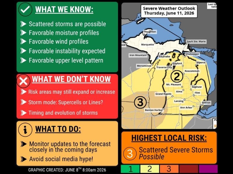
MICHIGAN — A potentially significant severe weather episode is shaping up for Michigan on Thursday June 11th, with the Storm Prediction Center placing the entire lower peninsula under a Level 2 Slight Risk and southwest Michigan including Grand Rapids, Benton Harbor, and Lansing under a Level 3 Enhanced Risk. The overall atmospheric pattern this week is highly supportive of squall line formation, with favorable moisture profiles, wind shear, instability, and upper-level pattern all aligned to support organized severe weather development.
Forecasters are flagging Thursday specifically as the day of greatest concern while noting that multiple days this week carry some severe weather potential across the state.
Southwest Michigan Under Level 3 Enhanced Risk as the Highest Threat Zone
The Level 3 Enhanced Risk zone centered over southwest Michigan including the Grand Rapids and Benton Harbor corridor represents a significant severe weather designation indicating organized and impactful storms are likely Thursday. Scattered severe storms are the highest local risk designation for this zone, capable of producing damaging winds, large hail, and potentially tornadoes depending on storm mode. The risk areas may still expand or increase further as Thursday approaches and forecast confidence improves with each model run.
Favorable Moisture Wind Shear and Instability All Supporting Organized Storms
Multiple atmospheric parameters are aligning favorably for Thursday’s severe weather setup, including strong moisture profiles, favorable wind shear for storm organization, expected instability, and a supportive upper-level pattern. What remains uncertain is the exact storm mode, specifically whether discrete supercells or linear squall line segments will dominate, as well as the precise timing and evolution of the storm activity.
Both storm modes carry significant severe weather potential, though the specific hazard profile differs between supercell and linear setups.
Monitor Updates Closely Through Wednesday and Avoid Overreacting to Social Media
Michigan residents across the entire lower peninsula should monitor daily forecast updates closely through Wednesday as confidence builds and the risk zones potentially expand or shift. Forecasters are specifically advising the public to avoid social media hype and instead follow official NWS and credible local meteorologist updates as the event approaches.
Thursday plans across Michigan should include a weather safety component and a shelter plan before storms arrive. Stay with NapervilleLocal.com for the latest weather updates and local forecast coverage.

I’ve lived in Naperville long enough to see how quickly our community changes — from new developments downtown to sudden shifts in our Midwest weather. Reporting on Naperville news and daily forecasts gives me the chance to keep neighbors informed about what really matters. My goal is simple: deliver clear, timely updates so you always know what’s happening in our city and what to expect from the skies above.