
Afternoon and Evening Storms With Gusty Winds and Frequent Lightning Target Greenville, Asheville, and Clemson as Southeast Heat Builds Toward Low-to-Mid 90s Friday
SOUTHEAST — A scorcher of a day is setting up across the Southeast this afternoon, with heat and humidity building through the day before scattered storms develop across portions of the region during the afternoon and evening hours. Not everyone will see a storm, but stronger storms will be possible as instability increases, with gusty winds and frequent lightning serving as the primary threats.
Heat and Humidity Dominate Before Storms Arrive
Conditions across the Southeast are carrying that classic summertime feel today, with heat and humidity combining to make it feel oppressive before any storm activity develops. The hottest and most humid part of the day will come during the early afternoon hours ahead of storm development.
Residents across the region should stay hydrated, limit prolonged outdoor exposure during peak heating, and keep an eye on the sky as conditions become more volatile through the afternoon.
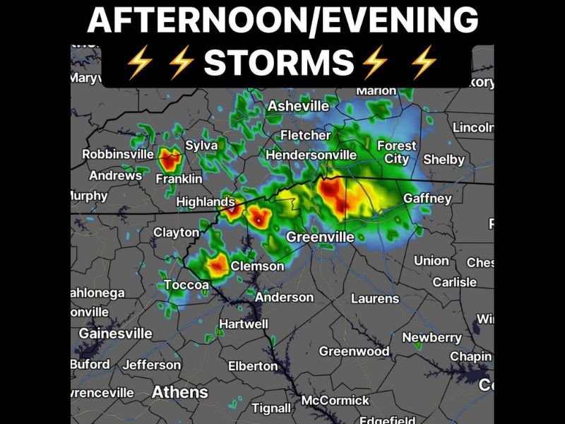
Stronger Storms Possible Across the Greenville and Asheville Corridor
The simulated radar highlights the most concentrated storm activity focused across the Highlands, Clemson, Greenville, and Hendersonville corridor, with additional activity possible near Asheville, Fletcher, and Forest City. Storms developing in this zone carry the highest potential for gusty winds and dangerous lightning.
Areas including Sylva, Franklin, Robbinsville, and Andrews to the west are also within range of isolated storm activity during the afternoon and evening window. Outdoor plans across this entire corridor should include a weather safety component.
Frequent Lightning Is a Serious Threat With These Storms
Frequent lightning is listed as a co-primary threat alongside gusty winds today, making it dangerous to be outdoors when storms are in the vicinity. Anyone caught outside when storms approach should seek sturdy shelter immediately and not wait for heavy rain to begin before moving indoors.
Looking ahead, the heat continues to build with Friday already showing signs of low-to-mid 90s across the Southeast. The overall pattern remains active and hot with additional storm chances likely through the end of the week. Stay with NapervilleLocal.com for the latest weather updates and local forecast coverage.

I’ve lived in Naperville long enough to see how quickly our community changes — from new developments downtown to sudden shifts in our Midwest weather. Reporting on Naperville news and daily forecasts gives me the chance to keep neighbors informed about what really matters. My goal is simple: deliver clear, timely updates so you always know what’s happening in our city and what to expect from the skies above.