
Tropical Storm Cristina Remnants Eyed for Gulf Development With Rain and Flooding Threat for Northern Mexico and South Texas as NHC Monitors 10% Chance
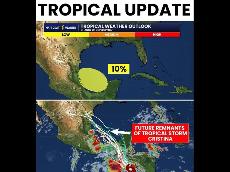
GULF OF MEXICO — The first National Hurricane Center area of interest of the season is now being tracked in the Southwestern Gulf, tied to the remnants of Tropical Storm Cristina. After Cristina makes landfall in Central America and falls apart, its leftover energy is expected to move into the Southwestern Gulf and Bay of Campeche, where forecasters are currently giving a low 10% chance of further tropical development as of Wednesday morning.
Cristina’s Remnants Heading Into the Bay of Campeche
Once Tropical Storm Cristina completes its landfall in Central America, the circulation is expected to break down and the remnant moisture will track northward into the Southwestern Gulf and Bay of Campeche. The NHC is monitoring this area carefully, though development odds currently sit at just 10% and remain subject to change in either direction as the system evolves.
Even without any further tropical development, the remnant energy carries enough moisture to produce significant weather impacts across portions of the region in the coming days.
Rain and Flooding Are the Main Concern for South Texas and Northern Mexico
Regardless of whether any tropical development occurs, rain and flooding are the primary concerns for northern Mexico and parts of South Texas. The moisture associated with Cristina’s remnants will be sufficient to produce heavy rainfall across these areas whether or not a named storm forms.
Residents in South Texas border communities should monitor forecasts closely over the coming days and be prepared for the possibility of heavy rainfall and localized flooding, particularly in low-lying and flood-prone areas.
No Threat to Florida at This Time
Forecasters are clear that this system poses no threat to Florida at this time. The development zone shown on the tropical weather outlook is confined to the western Gulf and Bay of Campeche, well removed from the Florida peninsula and the eastern Gulf Coast.
The overall situation remains low-key but worth watching, particularly for those in South Texas and northern Mexico where rain and flooding impacts are possible regardless of tropical development. Stay with NapervilleLocal.com for the latest weather updates and local forecast coverage.

I’ve lived in Naperville long enough to see how quickly our community changes — from new developments downtown to sudden shifts in our Midwest weather. Reporting on Naperville news and daily forecasts gives me the chance to keep neighbors informed about what really matters. My goal is simple: deliver clear, timely updates so you always know what’s happening in our city and what to expect from the skies above.