
Damaging Winds Up to 65 MPH Squall Line Targets Rockford, Chicago, Peoria, and Springfield as Severe Weather Saturday Sweeps Illinois From 4 PM Through 3 AM Sunday
ILLINOIS — Another round of severe weather is set to impact Illinois this Saturday, with a squall line expected to develop and sink southward through the state from late afternoon through the overnight hours. While this round will not be as intense as the past two nights, damaging winds up to 65 mph remain the primary hazard.
Impacts may be more elevated than usual given widespread tree damage and power outages already in place, and wet soils have loosened root systems making trees more prone to uprooting.
Northern Illinois From Rockford to Chicago Hit First Between 4 PM and 10 PM
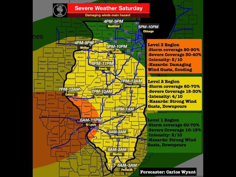
The squall line arrives first across northern Illinois, with Rockford under the gun from 4 PM to 9 PM and Chicago from 5 PM to 10 PM. The Level 3 region covering northern and central Illinois carries 80 to 90% storm coverage, 30 to 40% severe coverage, and an intensity rating of 5 out of 10.
Primary hazards in this zone are damaging wind gusts and flooding. Moline and LaSalle are also in this window from 4 to 5 PM onward, with Peoria following from 6 PM to 11 PM.
Central Illinois Springfield to Champaign Window 7 PM to Midnight
Central Illinois including Springfield, Quincy, and Champaign falls into the Level 2 region, with storm coverage of 60 to 70%, severe coverage of 15 to 30%, and an intensity of 4 out of 10. Strong wind gusts and downpours are the main hazards for this zone between 7 PM and midnight.
An upgrade to Enhanced Risk is possible across central Illinois if instability increases through the evening hours.
Southern Illinois Early Morning Storms Then Evening Squall Line
Southern Illinois including Effingham, Mt. Vernon, Marion, and Paducah faces an early morning storm window beginning at 8 AM with gusty winds and hail, clearing by 10 to 11 AM. The main squall line then arrives again between 8 PM and 3 AM Sunday for the southernmost portions of the state.
Tornado risk with this round is much lower than previous nights, but all warnings must still be taken seriously. Stay with NapervilleLocal.com for the latest weather updates and local forecast coverage.

I’ve lived in Naperville long enough to see how quickly our community changes — from new developments downtown to sudden shifts in our Midwest weather. Reporting on Naperville news and daily forecasts gives me the chance to keep neighbors informed about what really matters. My goal is simple: deliver clear, timely updates so you always know what’s happening in our city and what to expect from the skies above.