
Scattered Storms With Damaging Wind Gusts Possible Across North Carolina Including Raleigh, Charlotte, and Greenville Friday Afternoon Through Midnight as Heat Tops Low 90s
NORTH CAROLINA — It is already hot and humid across North Carolina this Friday morning, with most areas sitting in the 80s and low 90s before the afternoon heating even begins. Scattered showers and thunderstorms are expected to develop mainly after 3 PM and continue through the evening and early overnight hours.
While not everyone will see storms given the hit-or-miss scattered nature of the coverage, a limited severe risk is in place and a couple of stronger storms capable of damaging wind gusts cannot be ruled out.
Storms Fire After 3 PM With Greatest Coverage Across Central North Carolina
Storm development is expected to begin in earnest after 3 PM Friday, driven by the combination of intense afternoon heating and a front in the area. The greatest storm coverage through the afternoon and evening hours will be concentrated across the central portion of the state, with activity spreading and becoming more scattered through the evening.
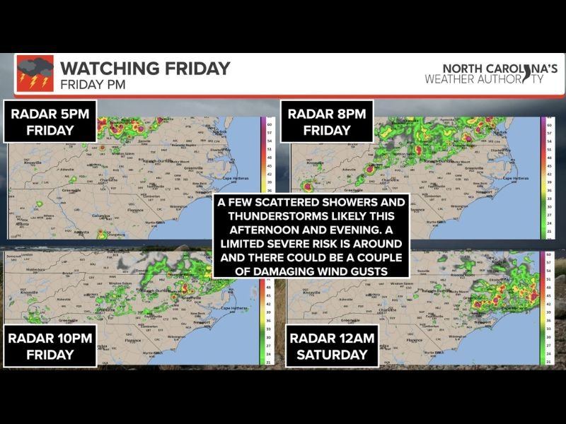
The simulated radar sequence shows storm activity present at 5 PM, continuing and evolving through 8 PM and 10 PM, with lingering activity still possible near midnight Saturday across portions of the state.
Damaging Wind Gusts Are the Main Severe Threat
While most storms will be garden-variety afternoon thunderstorms, the combination of extensive heating and the frontal boundary means a couple of stronger to potentially severe storms cannot be ruled out. Damaging wind gusts are identified as the primary severe threat from any storm that becomes more intense during the afternoon and evening hours.
Outdoor plans Friday afternoon and evening should include a weather awareness component. When thunder is heard, move indoors immediately and wait at least 30 minutes after the last rumble before returning outside.
Heat and Humidity Remain Oppressive Ahead of Storm Chances
Temperatures in the 80s and low 90s combined with high humidity are making conditions feel oppressive across the state well before any storms develop. Residents should stay hydrated, avoid prolonged outdoor exposure during peak afternoon heating, and never leave children or pets in vehicles.
Some areas lucky enough to receive rainfall today will get a brief but welcome cooling break from the heat. Stay with NapervilleLocal.com for the latest weather updates and local forecast coverage.

I’ve lived in Naperville long enough to see how quickly our community changes — from new developments downtown to sudden shifts in our Midwest weather. Reporting on Naperville news and daily forecasts gives me the chance to keep neighbors informed about what really matters. My goal is simple: deliver clear, timely updates so you always know what’s happening in our city and what to expect from the skies above.