
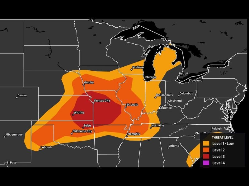
Enhanced Risk Level 3 Severe Weather Hits Missouri, Kansas, and Oklahoma With 75+ MPH Winds, Large Hail, and Tornadoes Possible in Multiple Rounds This Saturday
MISSOURI/KANSAS/OKLAHOMA — A Level 3 of 5 Enhanced Risk for severe weather is in place today, Saturday June 13, across Missouri, Kansas, and Oklahoma, with the threat already developing as leftover spin from overnight storms fires fresh activity ahead of an approaching cold front. Multiple rounds of severe weather are likely through the afternoon and evening, with damaging winds topping 75 mph serving as the headline hazard alongside large hail and a few tornadoes.
75+ MPH Damaging Winds Are the Primary Threat Today
As storms clump together into lines through the evening hours, wind gusts capable of snapping limbs and knocking out power are the dominant concern across the Enhanced Risk zone. Gusts reaching 75 mph or higher are possible as storm clusters organize and push eastward across Kansas City, Wichita, Tulsa, Oklahoma City, and into western and southwest Missouri.
The core Level 3 zone shown in deep red on the SPC outlook is centered over Kansas and Oklahoma, with the risk extending eastward through Missouri and northward toward Omaha. Anyone in this corridor should secure loose outdoor items and prepare for potential extended power outages.
Large Hail and Tornadoes Possible Mainly Late Afternoon Into Evening
Large hail and a few tornadoes are also on the table today, primarily during the late afternoon into evening hours across western and southwest Missouri as winds aloft increase significantly. Leftover spin from overnight storm activity across Oklahoma and Kansas will help fuel fresh storm development this afternoon as heat builds ahead of the cold front.
Discrete storm mode during the afternoon carries the greatest tornado potential before storms consolidate into damaging wind-producing line segments through the evening hours.
Multiple Rounds Expected — Do Not Let Your Guard Down
A key message for today is that multiple rounds of severe weather are likely. The first storm that passes through is not the last threat of the day. Each round will need to be monitored independently, and residents should remain weather aware from afternoon through the late evening hours.
Keep alerts active, have shelter plans ready, and do not assume the threat has passed after any single storm moves through. Stay with NapervilleLocal.com for the latest weather updates and local forecast coverage.

I’ve lived in Naperville long enough to see how quickly our community changes — from new developments downtown to sudden shifts in our Midwest weather. Reporting on Naperville news and daily forecasts gives me the chance to keep neighbors informed about what really matters. My goal is simple: deliver clear, timely updates so you always know what’s happening in our city and what to expect from the skies above.