
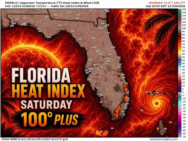
Heat Index Hitting 100°+ Statewide Across Florida With Panhandle Approaching 110° and Central Florida Topping 105° as Dangerous Heat Peaks This Saturday Afternoon
FLORIDA — A dangerous heat index event is unfolding across Florida this Saturday, June 13, with the NOAA HRRR model valid at 3:00 PM EDT showing heat index values of 100°F or higher across virtually the entire state. Several spots are approaching the mid-100s, with the Panhandle running as high as 109°F and central Florida widely in the 102 to 105°F range.
The extra atmospheric moisture is amplifying both the heat index values and the intensity of any afternoon storms that develop, particularly across the middle of the state.
Panhandle Running 100 to 109°F Heat Index at Peak Afternoon Hours
The most extreme heat index readings Saturday are across the Florida Panhandle, where values are reaching 100 to 109°F during the peak afternoon heating window. Actual air temperatures across the Panhandle are running 100 to 104°F, and the heavy moisture content in the atmosphere is pushing the apparent temperature to near-record dangerous levels.
Anyone outdoors across Pensacola, Panama City, and surrounding Panhandle communities during the afternoon hours faces serious heat stress. Outdoor activities should be suspended during peak heating and moved to early morning or after sunset.
Central Florida Widely 100 to 105°F Heat Index Saturday Afternoon
Across central Florida, the HRRR is showing heat index values broadly in the 100 to 105°F range during the 3 PM EDT timeframe. The Tampa, Orlando, and surrounding metro areas are all sitting in this dangerous zone, with the high humidity making the air feel oppressive even in shaded areas.
Storms developing across the middle of the state this afternoon will be extra intense given the elevated atmospheric moisture in place, capable of producing heavy rainfall and gusty winds for those that receive them.
South Florida and the Keys Running 94 to 102°F Heat Index
South Florida including Miami and Fort Lauderdale is running heat index values of 97 to 102°F Saturday afternoon, while the Keys are sitting in the 94 to 98°F range. Even coastal locations are not escaping the dangerous heat this weekend.
Stay hydrated, seek air conditioning during peak afternoon hours, and never leave children or pets in vehicles under any circumstances. Stay with NapervilleLocal.com for the latest weather updates and local forecast coverage.

I’ve lived in Naperville long enough to see how quickly our community changes — from new developments downtown to sudden shifts in our Midwest weather. Reporting on Naperville news and daily forecasts gives me the chance to keep neighbors informed about what really matters. My goal is simple: deliver clear, timely updates so you always know what’s happening in our city and what to expect from the skies above.