
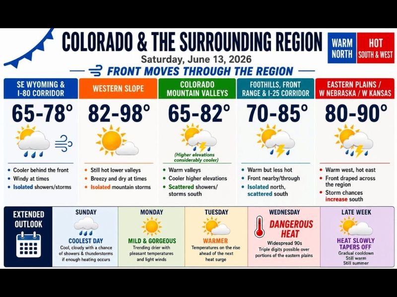
Cold Front Splits Colorado With Scattered Storms and Cooler Temps North While Western Slope Hits Near 98° Before Dangerous Heat and Triple Digits Return Wednesday
COLORADO — A cold front is sliding through Colorado and the surrounding region this Saturday, June 13, creating a dramatic split in conditions depending on which side of the boundary you sit on. Northern areas including SE Wyoming and the I-80 corridor are seeing cooler temperatures and isolated showers, while the Western Slope and southern zones remain hot, with some locations approaching 98°F. Looking ahead, a brief mild stretch gives way to dangerous heat returning Wednesday with widespread 90s and triple digits possible over the eastern plains.
Northern Colorado and Wyoming Cooler With Isolated Showers Today
SE Wyoming and the I-80 Corridor are sitting in the 65 to 78°F range today behind the front, with windy conditions and isolated showers and storms possible. The Front Range and I-25 Corridor is forecast to reach 70 to 85°F with the front nearby, bringing isolated storms to the north and scattered activity to the south.
Colorado Mountain Valleys are running 65 to 82°F with warm valleys and considerably cooler higher elevations, along with scattered showers and storms developing across southern areas through the afternoon.
Western Slope and Eastern Plains Staying Hot Saturday
The Western Slope is not feeling any cold front relief today, with temperatures climbing to 82 to 98°F in the lower valleys with breezy and dry conditions and isolated mountain storms possible. The Eastern Plains, western Nebraska, and western Kansas are forecast to reach 80 to 90°F with storm chances increasing across southern portions as the front drapes across the region.
Dangerous Heat Returns Wednesday With Triple Digits Possible
After a coolest day of the stretch on Sunday featuring clouds and storm chances, and a mild and gorgeous Monday with pleasant temperatures and light winds, the pattern turns sharply hotter. Temperatures begin rising Tuesday ahead of the next heat surge, and Wednesday brings dangerous heat with widespread 90s and triple digits possible over portions of the eastern plains.
Late next week brings a gradual cooldown, though conditions remain warm and firmly in summer territory with no significant relief in sight. Stay with NapervilleLocal.com for the latest weather updates and local forecast coverage.

I’ve lived in Naperville long enough to see how quickly our community changes — from new developments downtown to sudden shifts in our Midwest weather. Reporting on Naperville news and daily forecasts gives me the chance to keep neighbors informed about what really matters. My goal is simple: deliver clear, timely updates so you always know what’s happening in our city and what to expect from the skies above.