
Big Severe Weather Day Being Watched for Iowa, Illinois, Missouri, and Indiana With Derecho, Damaging Winds, and Tornadoes Possible Wednesday June 17
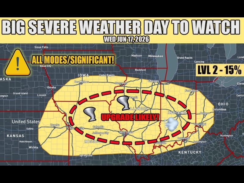
MIDWEST — Medium-range forecast guidance is in fairly strong agreement on a potent severe weather setup targeting Iowa, Illinois, Missouri, and Indiana on Wednesday, June 17. All severe weather modes are on the table for this event, with a derecho-type scenario featuring widespread damaging winds considered the minimum outcome at this stage. Shear and instability supporting tornadoes are also present in the setup, and forecasters are explicitly flagging an upgrade to the current risk level as likely as the event draws closer.
Derecho Scenario on the Table With All Severe Modes Possible
The current outlook carries a Level 2 probability with a 15% tornado risk across the highlighted zone, but that number is expected to climb significantly in the coming days. The core threat area shown by the dashed red boundary on the graphic is centered over Illinois and Missouri, extending into Iowa, Kansas City, and Indiana.
At the very least, a derecho-type event with widespread damaging winds is expected. A derecho is a long-lived, fast-moving line of severe thunderstorms capable of producing straight-line wind damage across hundreds of miles, similar in destructive potential to a moderate tornado but over a far larger area.
Tornadoes Also Supported by Shear and Instability
Beyond the wind threat, the shear and instability combination present in the Wednesday setup also supports tornado development. Whether tornadoes become a significant part of the event will depend on how storm mode unfolds — specifically whether discrete supercells can sustain themselves before any linear consolidation occurs.
Cities including Des Moines, Davenport, Peoria, Chicago, Kansas City, Jefferson City, Saint Louis, and Indianapolis all fall within or near the threat zone being monitored for this event.
Upgrade to Higher Risk Level Explicitly Flagged
Forecasters are not hedging on the potential severity of this event — an upgrade beyond the current Level 2 designation is considered likely as model guidance refines the setup over the coming days. Wednesday June 17 is shaping up to be one of the more significant severe weather days of the season for the Midwest.
Monitor forecasts closely through the week and have severe weather plans ready well in advance. Stay with NapervilleLocal.com for the latest weather updates and local forecast coverage.

I’ve lived in Naperville long enough to see how quickly our community changes — from new developments downtown to sudden shifts in our Midwest weather. Reporting on Naperville news and daily forecasts gives me the chance to keep neighbors informed about what really matters. My goal is simple: deliver clear, timely updates so you always know what’s happening in our city and what to expect from the skies above.