
Large Hail and Damaging Winds Threaten Fayetteville, Jonesboro, and Bentonville in Northern Arkansas With Two Storm Rounds From 6 PM Saturday
ARKANSAS — A multi-round severe weather threat is developing across northern Arkansas this evening and continuing through overnight into Sunday morning. The northern third of Arkansas faces the greatest risk, with two distinct storm windows expected between 6 PM Saturday and sunrise Sunday. Large hail and damaging winds are the primary hazards, with storms moving southeast out of Missouri and Kansas before gradually weakening as they push into central Arkansas overnight.
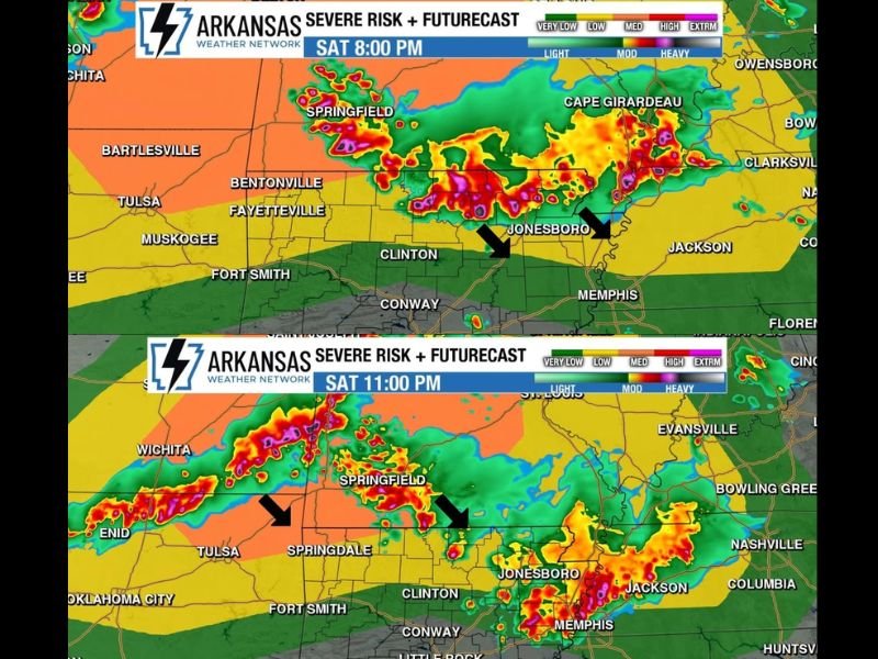
First Window 6 to 10 PM — Large Hail and High Winds Target North Central and Northeast Arkansas
The first severe weather window opens this evening between 6 and 10 PM, with storms moving southeast out of Missouri targeting north central and northeast Arkansas. The futurecast imagery at 8 PM shows heavy storm activity concentrated across the Fayetteville, Bentonville, Jonesboro, and Clinton corridor.
These storms are capable of producing large hail and high winds as they track southeastward. Residents across northern Arkansas should have shelter plans in place well before 6 PM this evening.
After Midnight — Storm Complex From Kansas and Missouri Enters Arkansas
The second round arrives after midnight as a larger storm complex pushes southeast out of Kansas and Missouri into Arkansas. Damaging winds are the primary threat with this overnight round, expected to be more widespread in coverage than the evening wave.
The futurecast sequence shows this complex moving through Fort Smith and Fayetteville around 2 AM Sunday, continuing southeastward through Conway, Little Rock, and toward Pine Bluff by 6 AM Sunday morning.
Storms Weaken Moving South — Widespread Rain Still Likely Sunday
As the overnight complex pushes into central Arkansas by sunrise Sunday, storms are expected to weaken compared to their intensity over northern portions of the state. However, this round represents the best chance for widespread rainfall across Arkansas this weekend, with moderate to locally heavy rain possible through Sunday morning.
Keep weather alerts active through the overnight hours and do not be caught off guard by the after-midnight storm arrival. Stay with NapervilleLocal.com for the latest weather updates and local forecast coverage.

I’ve lived in Naperville long enough to see how quickly our community changes — from new developments downtown to sudden shifts in our Midwest weather. Reporting on Naperville news and daily forecasts gives me the chance to keep neighbors informed about what really matters. My goal is simple: deliver clear, timely updates so you always know what’s happening in our city and what to expect from the skies above.