
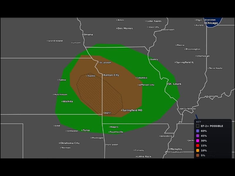
EF-2+ Tornadoes Possible From Joplin to Topeka and Kansas City as Tornado Probability Map Flags a Significant Threat Across Kansas and Missouri This Saturday
KANSAS/MISSOURI — A significant tornado threat is in place across Kansas and Missouri this Saturday, June 13, with EF-2 or stronger tornadoes explicitly possible across a focused corridor stretching from Joplin to Topeka and Kansas City. The Max Velocity Weather tornado probability map issued at 4:04 AM ET shows a well-defined threat zone centered over northeast Kansas and western Missouri, with the highest probabilities concentrated between Topeka, Kansas City, Joplin, and Springfield Missouri.
EF-2+ Tornado Zone Centered Over Topeka, Kansas City, and Joplin Corridor
The innermost hatched zone on the tornado probability map — indicating EF-2 or stronger tornado potential — is tightly focused over a corridor encompassing Topeka, Kansas City, Joplin, and Springfield Missouri. This is the area where atmospheric shear, instability, and boundary orientation are most favorable for sustaining discrete supercells capable of producing significant and potentially long-track tornadoes.
A 5% tornado probability zone shown in brown surrounds this EF-2+ corridor, extending from Salina and Wichita in Kansas northeastward through St. Joseph and Columbia Missouri. Anyone within this zone faces a meaningful tornado risk today.
Broader 2% Tornado Probability Extends Across a Wide Region
The outer green zone carrying a 2% tornado probability extends significantly further, reaching from Omaha and Des Moines southward through Oklahoma and eastward to St. Louis and Cape Girardeau. Cities including Lincoln, Quincy, Jefferson City, and Rogers fall within this broader threat area where isolated tornado development remains possible.
While the outer zone carries lower odds, the 2% threshold still represents a non-trivial tornado risk given the overall volatile atmospheric setup across the region today.
Stay Weather Aware Through the Afternoon and Evening Hours
The tornado threat today is not confined to a brief window — multiple rounds of severe weather are expected through the afternoon and evening hours across Kansas and Missouri. Any supercell that develops within the EF-2+ zone should be treated with extreme caution.
Have multiple ways to receive tornado warnings active on all devices, know your shelter location, and be ready to act immediately when warnings are issued today. Stay with NapervilleLocal.com for the latest weather updates and local forecast coverage.

I’ve lived in Naperville long enough to see how quickly our community changes — from new developments downtown to sudden shifts in our Midwest weather. Reporting on Naperville news and daily forecasts gives me the chance to keep neighbors informed about what really matters. My goal is simple: deliver clear, timely updates so you always know what’s happening in our city and what to expect from the skies above.