
Above Normal Rainfall Forecast for San Antonio, Corpus Christi, and South Texas With 2 to 5 Inches Possible Over the Next 7 Days Marking Third Straight Above Normal Month
SAN ANTONIO/SOUTH TEXAS — The Weather Prediction Center’s latest 7-day rainfall forecast is showing a significant and widespread precipitation event unfolding across San Antonio and much of South Texas over the next week. Totals ranging from 2 to 5 inches or more are forecast across a large swath of the region, easily pushing San Antonio and surrounding areas into above normal rainfall territory for June — what would mark the third consecutive month of above normal precipitation for the area.
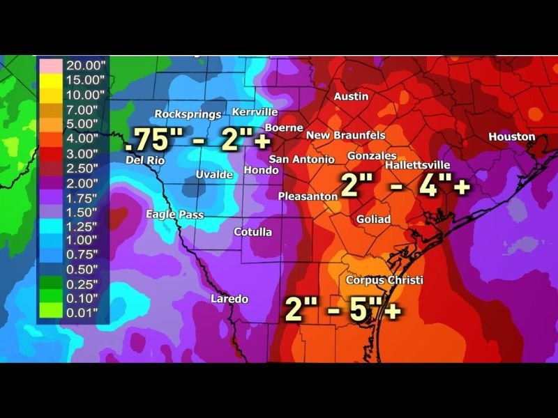
Corpus Christi and Coastal South Texas Facing the Heaviest Totals at 2 to 5 Inches Plus
The heaviest rainfall totals over the next seven days are forecast across the Corpus Christi area and coastal South Texas, where the WPC is showing 2 to 5 inches or more. This zone stretching from Goliad and Hallettsville southward through Corpus Christi and toward the coast carries the deepest rainfall signal on the forecast map, shown in the deep red and purple shading.
Flooding concerns will need to be monitored closely across this zone as rainfall accumulates over multiple days through the week ahead.
San Antonio to Gonzales and Hallettsville Corridor Running 2 to 4 Inches Plus
Across the San Antonio metro and eastward through Gonzales, New Braunfels, and Hallettsville, the 7-day rainfall forecast shows 2 to 4 inches or more. This corridor sits in the orange to red shading on the WPC map, reflecting a substantial multi-day rainfall accumulation that will push the region well above normal for the month of June.
Areas including Pleasanton, Hondo, Boerne, and Kerrville are also within the 2 to 4 inch zone through the coming week.
Western Areas From Del Rio to Uvalde Seeing 0.75 to 2 Inches Plus
Further west across the Del Rio, Uvalde, and Rocksprings corridor, rainfall totals are forecast at 0.75 to 2 inches or more over the seven-day period. While less dramatic than the coastal and central zones, these totals still represent meaningful precipitation for areas west of San Antonio.
Signs are emerging that the final week of June could turn less active across the region. Stay with NapervilleLocal.com for the latest weather updates and local forecast coverage.

I’ve lived in Naperville long enough to see how quickly our community changes — from new developments downtown to sudden shifts in our Midwest weather. Reporting on Naperville news and daily forecasts gives me the chance to keep neighbors informed about what really matters. My goal is simple: deliver clear, timely updates so you always know what’s happening in our city and what to expect from the skies above.