
Strong Tornadoes, Destructive Winds, and Very Large Hail Threatens Missouri, Illinois, and Indiana as Upgrade to Level 4 Likely Wednesday
MISSOURI/ILLINOIS/INDIANA — A potentially major severe weather outbreak is shaping up for Wednesday, June 17, with the Storm Prediction Center currently holding a Level 3 of 5 risk across Missouri, Illinois, and Indiana, though an upgrade to Level 4 is considered quite likely as details become clearer. An impressively deep surface low featuring winter-level jet stream energy overlapping with summer-level heat and dewpoints will create an environment supporting explosive thunderstorm development capable of strong tornadoes, destructive winds, and very large hail.
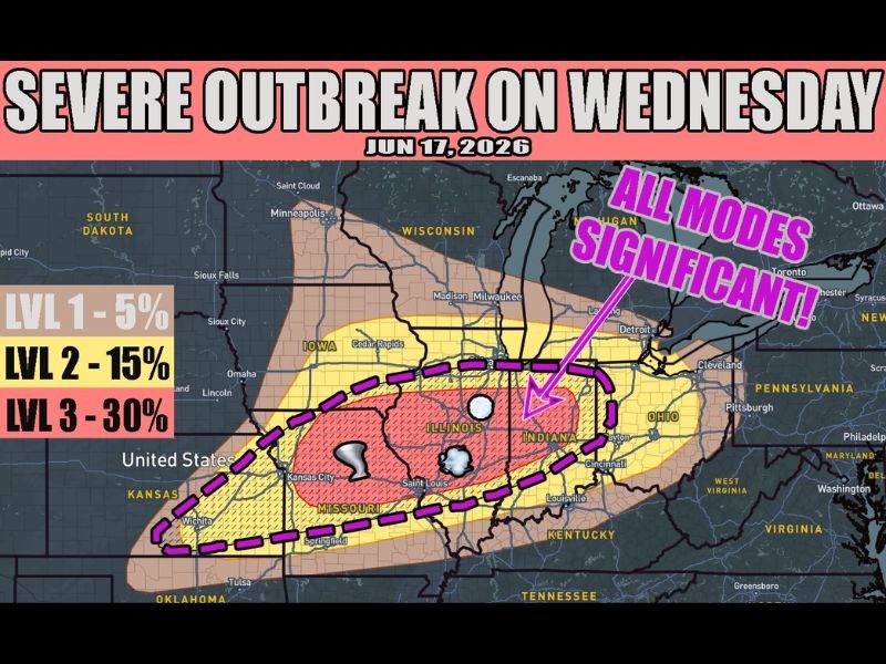
All Modes of Severe Weather Significant Across the Outbreak Zone
The graphic explicitly labels this event as having “all modes significant,” meaning tornadoes, damaging winds, and large hail are all considered substantial threats rather than just secondary concerns. The Level 3 zone with 30% probability is centered over central Missouri and Illinois, encompassing Kansas City, Springfield, St. Louis, and Indianapolis, with the broader Level 2 15% zone extending into Iowa, Wisconsin, Indiana, and Ohio.
The outer Level 1 5% zone stretches from South Dakota and Kansas through Pennsylvania, reflecting the massive scale of this developing system.
Storm Mode Uncertainty Is the Biggest Question Mark
The largest source of uncertainty in this setup comes down to storm mode. If longer-lived discrete supercells dominate, tornado chances increase significantly, including the potential for strong and long-track tornadoes. Alternatively, a faster transition to bow echoes and a squall line could produce a derecho scenario, with a long swath of destructive straight-line winds.
Regardless of which storm mode dominates, forecasters emphasize that the event will be intense either way given the depth of the surface low and the overlap of winter-level kinematics with summer thermodynamics.
Residents Should Prepare Now for a High-Impact Severe Weather Day
With an upgrade to Level 4 considered likely as the event approaches, residents across Missouri, Illinois, and Indiana should treat Wednesday as a high-impact severe weather day. Have shelter plans finalized, weather alerts active, and avoid making firm outdoor plans for Wednesday afternoon and evening.
Stay with NapervilleLocal.com for the latest weather updates and local forecast coverage.

I’ve lived in Naperville long enough to see how quickly our community changes — from new developments downtown to sudden shifts in our Midwest weather. Reporting on Naperville news and daily forecasts gives me the chance to keep neighbors informed about what really matters. My goal is simple: deliver clear, timely updates so you always know what’s happening in our city and what to expect from the skies above.