
Strong Low Pressure System Brings Breezy Conditions and Possible Severe Storms to the Carolinas Including Asheville, Greenville, and Hendersonville Thursday Into Friday
CAROLINAS — A low pressure system that may take on some tropical characteristics as Gulf moisture wraps into it is expected to arrive in the Carolinas Thursday into Friday, bringing breezy conditions, periods of rain, and an increased chance for thunderstorms. While this is not a tropical storm and bears no resemblance to past major tropical events, the combination of summer heat and humidity means some of these storms could become strong to severe given the additional wind energy associated with the system.
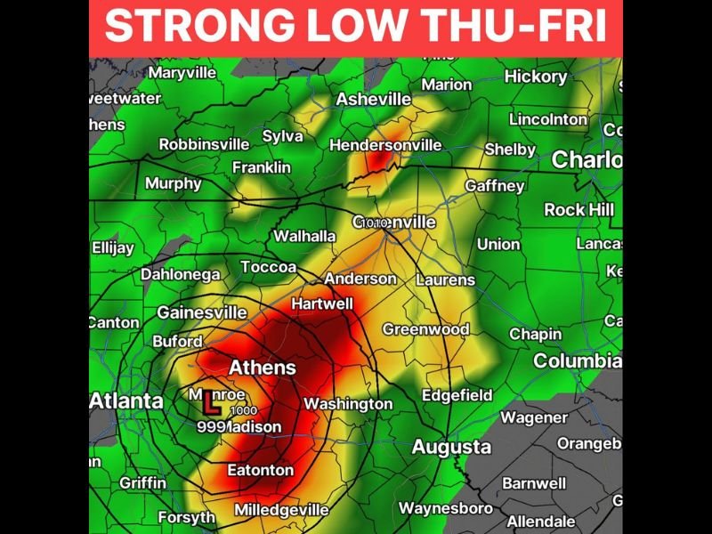
Strong Low Centers Over Georgia With Heaviest Rain Near Athens and Madison
The forecast model shows the low pressure center positioned over Georgia near Athens, Monroe, and Madison, with the most intense rainfall signatures in deep red surrounding this center. This area is showing the heaviest precipitation totals, with concentric pressure rings indicating a well-organized low pressure system.
Heavy rain bands extend outward from this center toward Hartwell, Anderson, and into the Greenville and Hendersonville area of South Carolina, where another area of heavier rainfall is indicated.
Carolinas Should Expect Breezy Conditions and Increased Storm Chances
For the Carolinas, including Asheville, Greenville, Hendersonville, and surrounding communities, the system’s approach Thursday into Friday will bring breezy conditions, periods of rain, and storms that have the potential to organize more than typical summertime pop-up activity due to the wind energy involved.
The hope among forecasters is that the region stays on the calmer side of this system, picking up beneficial rainfall without significant severe weather impacts. However, the setup is worth watching closely as Thursday and Friday approach.
Milder Weather Monday Through Wednesday Before Pattern Turns Active
Ahead of this system, the Carolinas will enjoy a stretch of milder weather Monday through Wednesday. Conditions are expected to turn more active and stormy starting Thursday as the low pressure system approaches from the south and west. Stay with NapervilleLocal.com for the latest weather updates and local forecast coverage.

I’ve lived in Naperville long enough to see how quickly our community changes — from new developments downtown to sudden shifts in our Midwest weather. Reporting on Naperville news and daily forecasts gives me the chance to keep neighbors informed about what really matters. My goal is simple: deliver clear, timely updates so you always know what’s happening in our city and what to expect from the skies above.