
Dangerous Heat and High Fire Danger Sweep Colorado’s Western Slope, Pueblo, and Front Range With 95 to 105°F Temps and 50 MPH Gusts Peaking This Wednesday
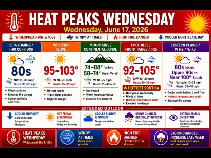
COLORADO — Heat peaks across Colorado and the surrounding region this Wednesday, June 17, with widespread 90s and 100s expected across most of the state combined with gusty winds and high fire danger. The Western Slope is the hottest zone today at 95 to 103°F with triple digits possible, while the Foothills, Front Range, and I-25 corridor are forecast to reach 92 to 105°F with the hottest readings concentrated in the southern portions. A cold front will begin working southward into SE Wyoming and far northern Colorado late today, bringing some cooler air from the north.
Front Range and Southern I-25 Corridor Reaching 92 to 105°F
The Foothills, Front Range, and I-25 corridor are forecast for 92 to 105°F today, with the hottest readings south along the corridor including the Pueblo to Lamar zone along Highway 50, which could end up being one of the hottest spots in the entire region. South to southwest winds at 10 to 20 mph with gusts to 35 mph combined with low humidity are creating elevated fire danger across this zone.
Western Slope Hottest Region With Triple Digits and High Fire Danger
The Western Slope is the hottest region today at 95 to 103°F, with west winds at 10 to 20 mph and gusts reaching 25 to 35 mph. High fire danger is in effect across the Western Slope, and any activity that could spark a fire should be avoided entirely through the afternoon and evening hours.
SE Wyoming and Northern Colorado See Cooler Temps and 35 to 50 MPH Gusts
SE Wyoming and the I-80 Corridor are forecast for temperatures in the 80s, with northwest winds at 15 to 30 mph and gusts reaching 35 to 50 mph. Elevated fire danger remains in place here as well despite the relatively cooler temperatures.
Looking ahead, cooler conditions return Thursday behind the front before heat rebounds Friday and Saturday. Storm chances gradually increase into the weekend with details still uncertain.
Stay with NapervilleLocal.com for the latest weather updates and local forecast coverage.

I’ve lived in Naperville long enough to see how quickly our community changes — from new developments downtown to sudden shifts in our Midwest weather. Reporting on Naperville news and daily forecasts gives me the chance to keep neighbors informed about what really matters. My goal is simple: deliver clear, timely updates so you always know what’s happening in our city and what to expect from the skies above.