
Enhanced Risk Severe Weather With 60 to 70+ MPH Winds and Tornadoes Targets Dayton, Springfield, and Greenville Ohio With Main Storm Window Running 10 PM to 4 AM Tonight
OHIO — A Level 3 Enhanced Risk for severe weather is in place for western and central Ohio tonight, with the main round of severe storms expected to impact the region between 10 PM and 4 AM. Damaging winds of 60 to 70+ mph are the primary hazard, with a few tornadoes — possibly strong — and large hail also on the table. With this being a nighttime event when most residents are asleep, meteorologists are urging everyone to charge battery banks and ensure weather alerts are active on all devices before going to bed tonight.
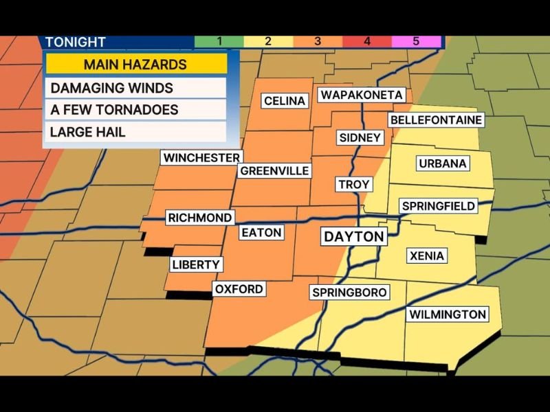
Enhanced Risk Zone Covers Dayton, Springfield, Greenville, and Troy
The Level 3 Enhanced Risk zone is centered over a corridor covering Dayton, Troy, Springfield, Urbana, Greenville, Sidney, Xenia, Eaton, Springboro, and Wilmington. This area faces the highest local probability for damaging wind gusts of 60 to 70+ mph, tornadoes, and large hail during the overnight storm window.
A Level 2 Slight Risk surrounds the Enhanced Risk core, extending toward Richmond, Liberty, Oxford, Winchester, Bellefontaine, Wapakoneta, Celina, and beyond.
County-by-County Storm Timing From 9 PM to 4 AM
The most likely window for the main round of severe storms varies by county. Mercer and Auglaize counties are earliest at 9 PM to 2 AM. Most Ohio counties including Champaign, Clark, Darke, Greene, Logan, Miami, Montgomery, Preble, Randolph, Shelby, Fayette, and Union are forecast for 10 PM to 3 AM. Butler, Clinton, and Warren counties fall slightly later at 11 PM to 4 AM.
Indiana counties including Fayette, Randolph, Union, and Wayne are also in the 10 PM to 3 AM window.
Nighttime Timing Demands Immediate Preparation Now
The overnight timing of this event significantly elevates the danger because most residents will be asleep when warnings are issued. A rogue strong storm before sunset tonight is possible but low confidence. The main event arrives after 10 PM.
Charge all devices now, enable wireless emergency alerts, and know your shelter location before going to bed tonight.
Stay with NapervilleLocal.com for the latest weather updates and local forecast coverage.

I’ve lived in Naperville long enough to see how quickly our community changes — from new developments downtown to sudden shifts in our Midwest weather. Reporting on Naperville news and daily forecasts gives me the chance to keep neighbors informed about what really matters. My goal is simple: deliver clear, timely updates so you always know what’s happening in our city and what to expect from the skies above.