
Tropical System Brings Heavy Rain to Houston, Pearland, and Galveston This Morning With System Passing Near Galveston Island and Rain Diminishing by Late Morning
HOUSTON/GALVESTON — A tropical system is bringing widespread rainfall to central and southern portions of Houston and the surrounding region this morning, with the system expected to pass near Galveston Island later today. Winds are expected to remain mostly modest with this passage, and rainfall across the Houston region is forecast to diminish by late morning or early afternoon as the system moves through.
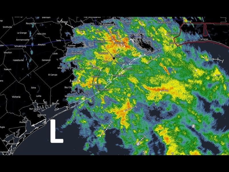
Heavy Rain Bands Covering Houston Metro and Galveston Bay Area
Live radar shows an extensive area of moderate to heavy rainfall blanketing the Houston metro this morning, with the most intense cores concentrated across Pearland, Baytown, Texas City, Galveston, and League City. Additional heavy bands are pushing through Katy, Fulshear, Rosenberg, and Lake Jackson south of the main metro area.
The low pressure center marked on radar is positioned offshore south of Galveston, with the associated rain shield extending northward across the entire Houston area and eastward through Beaumont, Port Arthur, and Sabine Pass where a red severe weather boundary is also visible.
Winds Mostly Modest as System Passes Near Galveston Island
Unlike more intense tropical systems, winds associated with today’s system are expected to remain mostly modest as it tracks near Galveston Island. The primary impact across the Houston region today is the rainfall rather than wind, which is typical for weaker tropical systems passing at this distance from the coast.
Residents should still monitor conditions closely as any tropical moisture interaction can produce locally heavy and training rainfall bands that increase flooding potential in low-lying and urban areas.
Rain Expected to Diminish by Late Morning Into Early Afternoon
The good news for the Houston region is that the rainfall is expected to diminish by late morning or early afternoon as the tropical system completes its passage near Galveston Island and continues tracking northeastward toward Louisiana. Areas east of Houston including Beaumont and Port Arthur will likely see continued rainfall longer as the system moves in that direction.
Avoid flooded roadways through the morning hours and allow extra time for travel until conditions improve later today. Stay with NapervilleLocal.com for the latest weather updates and local forecast coverage.

I’ve lived in Naperville long enough to see how quickly our community changes — from new developments downtown to sudden shifts in our Midwest weather. Reporting on Naperville news and daily forecasts gives me the chance to keep neighbors informed about what really matters. My goal is simple: deliver clear, timely updates so you always know what’s happening in our city and what to expect from the skies above.