
Violent Weather Day With TORCON 7 and Intense EF3+ Tornadoes Targets Peoria, Champaign, Bloomington, and Lafayette With 75+ MPH Winds and 2″+ Hail Possible Through Tonight
ILLINOIS/INDIANA — A violent severe weather outbreak is underway and expected to intensify significantly by midday today across Illinois and Indiana, with a TORCON of 7 — a medium to high risk for large, destructive, and long-track tornadoes. Intense EF3+ tornadoes are explicitly possible across a large swath centered over Peoria, Bloomington, Champaign, Watseka, Bourbonnais, Lafayette, and Monticello. A bow echo this morning has already produced winds exceeding 90 mph, but the atmosphere is expected to recover enough to produce a very intense outbreak by midday.
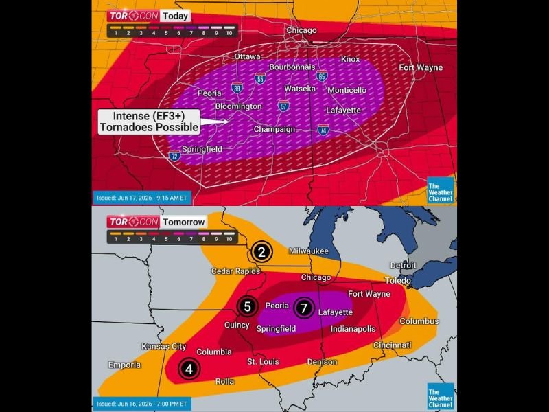
EF3+ Tornado Zone Covers Central Illinois and Indiana Corridor
The TORCON map today shows the highest tornado risk zone in deep purple centered over central Illinois and extending into Indiana, encompassing Ottawa, Peoria, Bloomington, Champaign, Watseka, Bourbonnais, Monticello, and Lafayette. Intense EF3+ tornadoes are labeled as possible within this zone — the kind of tornadoes capable of catastrophic structural damage.
Areas from Michigan and Ohio westward through Missouri should also remain on alert for numerous tornadoes, along with hail exceeding 2 inches in diameter and straight-line wind gusts in excess of 75 mph.
Outbreak Intensifies by Midday and Continues Past Dark
Despite morning bow echo activity, the atmosphere is forecast to recover sufficiently to produce a very intense severe weather outbreak by midday. Severe thunderstorms and tornadoes could continue for several hours past dark, creating an especially dangerous overnight scenario.
Mobile homes are explicitly not safe in these circumstances. Anyone living in a mobile or manufactured home must find alternate sturdy refuge before storms arrive this afternoon.
Tomorrow Continues Elevated Threat With TORCON 7 Centered on Lafayette
The threat does not end today. Tomorrow’s TORCON map shows a 7 centered over Lafayette and Peoria, a 5 near Quincy and Springfield, and a 4 extending into the Kansas City and Missouri corridor. Chicago sits at a TORCON 2 tomorrow.
Keep phones nearby through the night, alerts active, and do not go to bed without knowing your shelter plan is ready. Stay with NapervilleLocal.com for the latest weather updates and local forecast coverage.

I’ve lived in Naperville long enough to see how quickly our community changes — from new developments downtown to sudden shifts in our Midwest weather. Reporting on Naperville news and daily forecasts gives me the chance to keep neighbors informed about what really matters. My goal is simple: deliver clear, timely updates so you always know what’s happening in our city and what to expect from the skies above.